Ficheru:Europe map 1648-es.png

Tamañu d'esta previsualización: 800 × 577 pixels. Otres resoluciones: 320 × 231 pixels | 640 × 462 pixels | 1024 × 739 pixels | 1280 × 924 pixels | 1894 × 1367 pixels.
Ficheru orixinal (1894 × 1367 píxels, tamañu de ficheru: 141 kB, triba MIME: image/png)
| Descripción |
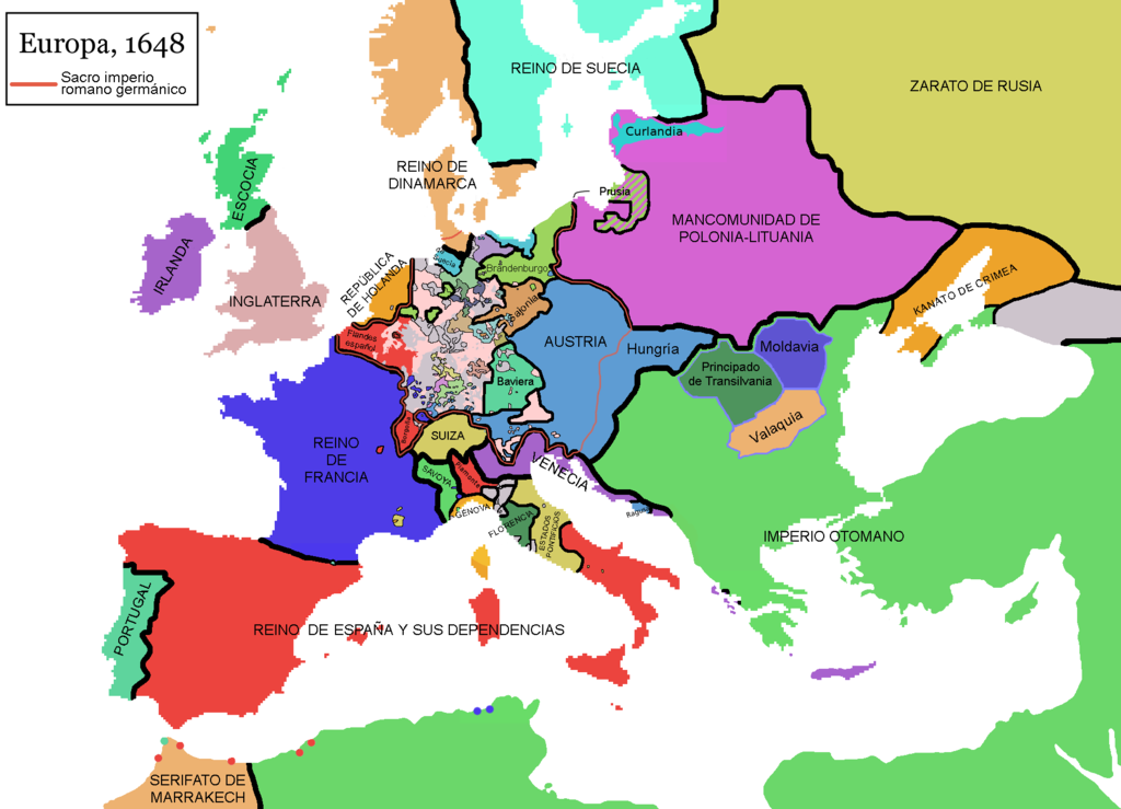
English: Map of Europe in 1648, at the end of the Thirty Years War. Red line marks the border of the Holy Roman Empire. (Labels in Spanish).
Español: Mapa de Europa en 1648, al final de la guerra de los treinta años. La línea roja marca las fronteras del Sacro imperio romano germánico.
Falta por cambiar el nombre de Piamonte, que es erroneo, la zona es el Milanesado o Ducado de Milan |
| Data | (UTC) |
| Fonte | |
| Autor |
|
| Esta ye una imaxe retocada, lo que significa que foi modificada dixitalmente de la so versión orixinal. Modificaciones: Rótulos en español (labels in Spanis) + Hungría. La orixinal pue vese equí: Europe map 1648.PNG:
|
Yo, el titular de los drechos d'autor d'esta obra, la espublizo baxo les siguientes llicencies:
| Esti ficheru ta disponible baxo la llicencia Creative Commons Reconocimientu-Compartir igual 3.0 xenérica. | ||
| ||
| Esta etiqueta de llicencia s'amestó a esti ficheru como parte del anovamientu de la llicencia GFDL. |

|
Autorízase la copia, distribución y/o cambéu d'esti documentu baxo los términos de la Llicencia de documentación llibre GNU, versión 1.2 o cualesquier otra que nel futuru espublice la Free Software Foundation; ensin seiciones invariables, testos de portada, nin testos de contraportada. S'inclúi una copia de la llicencia na seición titulada GNU Free Documentation License. |
Pues seleicionar la llicencia que prefieras.
Rexistru de xubíes orixinal
This image is a derivative work of the following images:
- File:Europe_map_1648.PNG licensed with Cc-by-sa-3.0-migrated, GFDL
- 2010-09-25T11:40:35Z Fakirbakir 1894x1367 (197540 Bytes) Minor
- 2010-09-25T10:45:19Z Fakirbakir 1894x1367 (197532 Bytes) Transylvania Moldavia and Wallachia were a 'semi-independent' state under the suzerainty of the Ottoman Empire.
- 2008-12-12T02:13:45Z Mathiasrex 1894x1367 (197990 Bytes) In 1648 Duchy of Prussia was yet a fief of the Polish Crown
- 2008-11-04T22:12:11Z Beliar 1894x1367 (197454 Bytes) Holstein was part of the HRE but was ruled by the danish king in personal union as the duce of H.
- 2007-10-24T07:09:47Z Conscious 1894x1367 (186157 Bytes) "Tsardom of Russia" instead of "Russian Empire" (this is a pre-1721 map)
- 2007-01-10T05:47:14Z Roke 1894x1367 (186110 Bytes) more detail HRE, fixes
- 2006-06-08T00:10:58Z Roke 1894x1367 (186146 Bytes) change to polish-lithuanian commonwealth after comment on en
- 2006-05-09T09:08:45Z Roke 1894x1367 (184339 Bytes) cropped right version
- 2006-05-08T13:12:58Z Roke 1894x1374 (111881 Bytes) minor crop
- 2006-05-05T05:12:47Z Roke 1900x1378 (185935 Bytes) Map of Europe in 1648 (at the end of the [[w:Thirty Years War|Thirty Years War]], based on free map of europe [[:Image:BlankMap-Europe.png]] {{Europe}} [[Category:Historical maps of Europe]]
Uploaded with derivativeFX
Historial del ficheru
Calca nuna fecha/hora pa ver el ficheru como taba daquella.
| Data/Hora | Miniatura | Dimensiones | Usuariu | Comentariu | |
|---|---|---|---|---|---|
| actual | 11:48 10 pay 2017 | | 1894 × 1367 (141 kB) | Raderich | Corregidos algunos errores en el mapa. |
| 15:52 9 set 2017 |  | 1894 × 1367 (134 kB) | Daniel Medina | Corregidas algunas erratas heredadas de la imagen original en inglés de 2010 en base a la versión de 2017 de la misma imagen (Media:Europe_map_1648.PNG. Concretamente se añaden: • la anexión de Cataluña por parte de Francia • enclaves f... | |
| 14:23 3 may 2013 |  | 1894 × 1367 (121 kB) | Osado | Label improvement; Burgundia → Borgoña | |
| 14:15 3 may 2013 |  | 1894 × 1367 (150 kB) | Osado | Reverted to version as of 11:31, 4 August 2011 | |
| 09:57 2 may 2013 |  | 1894 × 1367 (121 kB) | Osado | Label improvement; Burgundia → Borgoña | |
| 11:31 4 ago 2011 |  | 1894 × 1367 (150 kB) | Osado | {{Information |Description={{en|Map of Europe in 1648, at the end of the Thirty Years War. Red line marks the border of the Holy Roman Empire. (Labels in Spanish).}} {{es|Mapa de Europa en 1648, al final de la guerra de los treinta años. La línea roja m |
Usu del ficheru
Les páxines siguientes usen esti ficheru:
Usu global del ficheru
Estes otres wikis usen esti ficheru:
- Usu en es.wikipedia.org
- Usu en es.wikibooks.org
- Usu en eu.wikipedia.org
- Usu en pt.wikipedia.org
- Usu en www.wikidata.org
- Usu en wuu.wikipedia.org