Ficheru:Great Moravia-no labels.png

Tamañu d'esta previsualización: 707 × 600 pixels. Otres resoluciones: 283 × 240 pixels | 566 × 480 pixels | 906 × 768 pixels | 1208 × 1024 pixels | 1323 × 1122 pixels.
Ficheru orixinal (1323 × 1122 píxels, tamañu de ficheru: 403 kB, triba MIME: image/png)
Resume
| Descripción | Historical map of Great Moravia |
| Data | 2 de xunetu de 2007 (fecha de carga) |
| Fonte | Trabayu propiu; based on Image:Europe-slk.svg (which is based on CIA World Factbook (image), geodesy.gov.sk, Wikipedia (Slovak labels)) |
| Autor | Bronto, ~~Helix84 |
| Otres versiones | see below |
This cropped image is exported from the vector source: Image:Great Moravia not cropped, no labels.svg
All related images (exported from same source):
-
 Vector source, no labels
 -
 Vector source, German labels
 -
 Vector source, English labels
 -
 Vector source, French labels
 -
 Vector source, Slovak labels
 -
 Vector source, Polish labels
 -
 Cropped export, no labels
 -
 Cropped export, German labels
 -
 Cropped export, English labels
 -
 Cropped export, French labels
 -
 Cropped export, Polish labels
 -
 Cropped export, Slovak labels


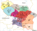
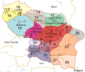
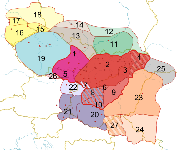
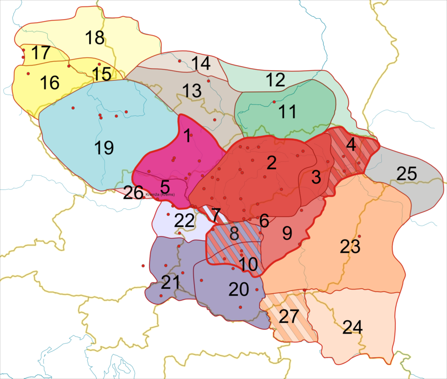
Slovenčina: Legenda:
1: od 833 do 907: Moravské kniežatstvo
2: od 833 do 907: Nitrianske kniežatstvo
3: spolu s  2 alebo spolu s 4
4: od 833 alebo od vlády Rastislava do (?)896: Nitrianske kniežatstvo
5: spolu s 1 alebo od roku 853/54 do (?)907: Moravské kniežatstvo
6: od roku 858 do (?)894: Nitrianske kniežatstvo
7: spolu s 2 alebo spolu s 22:
8: spolu s 6 alebo spolu s 20
9: od vlády Rastislava (846-870) alebo Svätopluka I. (871-894) do 896: Nitrianske kniežatstvo
10: spolu s 8 alebo spolu s 20
11: od 874 do (?) 907: Visliansko
12: pravdepodobne spolu s 11
13: od 880 do ?: Sliezsko (podľa niektorých názorov nebolo pripojené)
14: pravdepodobne spolu s 14
15: od 890 do 897: Lužica
16: veľmi pravdepodobne spolu s 15
17: veľmi pravdepodobne spolu s 15
18: pravdepodobne spolu s 15-17
19: od 888/890 do 894: Čechy
20: od 883/884 do 894: Panónske kniežatstvo
21: veľmi pravdepodobne spolu s 20
22: spolu s 20 (a 21): možno Panónske kniežatstvo
23: od 881/882 do 896: Zátisie
24: pravdepodobne spolu s 23
25: od vlády Svätopluka (871-894) do (?) 896
26: od vlády Svätopluka (871-894) do ?
27: spolu s 23 alebo spolu s 24
English:
Legend:
yellow lines: current borders
blue lines: rivers
red dots: main castles/settlements
1: from 833 to 907: Principality of Moravia
2: from 833 to 907: Principality of Nitra
3: along with 2 or along with 4
4: from 833 or from the reign of Rastislav to (?)896: Principality of Nitra
5: along with 1 or from 853/54 to (?)907: Princiaplity of Moravia
6: from 858 to (?)894: Principality of Nitra
7: along with 2 or along with 22
8: along with 6 or along with 20
9: from the reign of Rastislav (846-870) or of Svätopluk I (871-894) to 896: Principality of Nitra
10: along with 8 or along with 20
11: from 874 to (?) 907: Wislania
12: probably along with 11
13: from 880 to ?: Silesia (Silesia was not annexed according to some authors)
14: probably along with 14
15: from 890 to 897: Lusatia
16: with a high probability along with 15
17: with a high probability along with 15
18: probably along with 15-17
19: from 888/890 to 894: Bohemia
20: from 883/884 to 894: Pannonian Principality (Balaton Principality)
21: with a high probability along with 20
22: along with 20 (and 21): maybe part of the Pannonian Principality (Balaton Principality)
23: from 881/882 to 896: "Transtheissia"
24: probably along with 23
25: from the reign of Svätopluk (871-894) to (?) 896
26: from the reign of Svätopluk (871-894) to ?
27: along with 23 or along with 24
Deutsch:
Legende:
gelbe Linien: aktuelle Grenzen
blaue Linien: Flüsse
rote Punkte: die wichtigsten Burgwälle/Siedlungen
1: von 833 bis 907: Mährisches Fürstentum
2: von 833 bis 907: Neutraer Fürstentum
3: zusammen mit 2 oder zusammen mit 4
4: von 833 oder von der Regierungszeit Rastislavs bis (?)896: Neutraer Fürstentum
5: zusammen mit 1 oder von 853/54 bis (?)907: Mährisches Fürstentum
6: von 858 bis (?)894: Neutraer Fürstentum
7: zusammen mit 2 oder zusammen mit 22
8: zusammen mit 6 oder zusammen mit 20
9: von der Regierungszeit Rastislavs (846-870) oder Sventopluks I. (871-894) bis 896: Neutraer Fürstentum
10: zusammen mit 8 oder zusammen mit 20
11: von 874 bis (?) 907: Wislanenland
12: wahrscheinlich zusammen mit 11
13: von 880 bis ?: Schlesien (Schlesien wurde einigen Autoren zufolge nicht angeschlossen)
14: wahrscheinlich zusammen mit 14
15: von 890 bis 897: Lausitz
16: höchstwahrscheinlich zusammen mit 15
17: höchstwahrscheinlich zusammen mit 15
18: wahrscheinlich zusammen mit 15-17
19: von 888/890 bis 894: Bohemia
20: von 883/884 bis 894: Plattensee-Fürstentum
21: höchstwahrscheinlich zusammen mit 20
22: zusammen mit 20 (und 21): vielleicht Teil des Plattensee-Fürstentums
23: von 881/882 bis 896: "Transtheissia"
24: wahrscheinlich zusammen mit 23
25: von der Regierungszeit Sventopluks (871-894) bis (?) 896
26: von der Regierungszeit Sventopluks (871-894) bis ?
27: zusammen mit 23 oder zusammen mit 24
Français :
Légende:

Lignes jaunes: frontières actuelles
Lignes bleues: rivières
Points rouges: châteaux forts principaux/colonies principales
1: de 833 à 907: Principauté de Moravie
2: de 833 à 907: Principauté de Nitra
3: en même temps que 2 ou en même temps que 4
4: de 833 ou du règne de Rastislav à (?)896: Principauté de Nitra
5: en même temps que 1 ou de 853/54 à (?)907: Principauté de Moravie
6: de 858 à (?)894: Principauté de Nitra
7: en même temps que 2 ou en même temps que 22
8: en même temps que 6 ou en même temps que 20
9: du règne de Rastislav (846-870) ou de Svätopluk I (871-894) to 896: Principauté de Nitra
10: en même temps que 8 ou en même temps que 20
11: de 874 à (?) 907: Pays des Vistuliens
12: probablement en même temps que 11
13: de 880 à ?: Silésie (la Silésie n‘a pas été annexée d’après quelques auteurs)
14: probablement en même temps que 14
15: de 890 à 897: Lusatie
16: très probablement en même temps que 15
17: très probablement en même temps que 15
18: probablement en même temps que 15-17
19: de 888/890 à 894: Bohême
20: de 883/884 à 894: Principauté de Pannonie
21: très probablement en même temps que 20
22: en même temps que 20 (and 21): peut-être une partie de la Principauté de Pannonie
23: de 881/882 à 896
24: probablement en même temps que 23
25: du règne de Svätopluk (871-894) à (?) 896
26: du règne de Svätopluk (871-894) à ?
27: en même temps que 23 ou en même temps que 24
Main sources:
Čaplovič, Dušan: Včasnostredoveké osídlenie Slovenska, 1998, Bratislava
Dvořák, Pavel: Stopy dávnej minulosti – Zrod národa, 2004, Bratislava
Frolík, Jan et al.:  Velké dějiny zemí Koruny české I., 1999, Praha
Gurňák, Daniel: Štáty v premenách storočí – Dejepisný atlas, 2006, Bratislava
Kováč, Dušan et al.: Kronika Slovenska 1., 1998, Bratislava
Marsina, Richard et al.:  Dejiny Slovenska I., 1986, Bratislava
Ratkoš, Peter: Slovensko v dobe veľkomoravskej, 1988, Košice
Segeš, Vladimír; Višváder, František: Kniha kráľov - Panovníci v dejinách Slovenska a Slovákov, 1998, Bratislava
Steinhübel, Ján: Nitrianske kniežatstvo, 2004, Bratislava
Štefanovičová, Tatiana: Osudy starých Slovanov, 1989, Bratislava
Třeštík, Dušan: Vznik Velké Moravy. Moravané, Čechové a střední Evropa v letech 781-871, 2001, Praha
Licensing
I, Helix84, titular de los drechos d'autor d'esta obra, la espubliza baxo les siguientes llicencies:

|
Autorízase la copia, distribución y/o cambéu d'esti documentu baxo los términos de la Llicencia de documentación llibre GNU, versión 1.2 o cualesquier otra que nel futuru espublice la Free Software Foundation; ensin seiciones invariables, testos de portada, nin testos de contraportada. S'inclúi una copia de la llicencia na seición titulada GNU Free Documentation License. |
| Esti ficheru ta disponible baxo la llicencia Creative Commons Reconocimientu-Compartir igual 3.0 xenérica. | ||
| Reconocimientu: I, Helix84 | ||
| ||
| Esta etiqueta de llicencia s'amestó a esti ficheru como parte del anovamientu de la llicencia GFDL. |
Este archivo está disponible bajo la licencia Creative Commons Reconocimiento 2.5 Genérica.
Reconocimientu: I, Helix84
- Ye llibre:
- pa compartir – pa copiar, distribuir y comunicar públicamente la obra
- pa remezclar – p'adautar la obra
- Baxo les condiciones siguientes:
- reconocimientu – Tienes de dar el créitu apropiáu, apurrir un enllaz a la llicencia ya indicar si realizasti dalgún cambéu. Puedes faelo de cualquier mou razonable ,pero non de manera que suxera l'encontu del autor pa ti o pal usu que faigas.
Pues seleicionar la llicencia que prefieras.
Historial del ficheru
Calca nuna fecha/hora pa ver el ficheru como taba daquella.
| Data/Hora | Miniatura | Dimensiones | Usuariu | Comentariu | |
|---|---|---|---|---|---|
| actual | 00:57 2 xnt 2007 | | 1323 × 1122 (403 kB) | Helix84 | {{Information |Description=Historical map of Great Moravia, version without labels |Source=self-made; see details in Image:Great Moravia not cropped.svg; this is a png exported from vector graphics |Date=2.7.2007 |Author= [[:sk:us |
Usu del ficheru
La páxina siguiente usa esti ficheru:
Usu global del ficheru
Estes otres wikis usen esti ficheru:
- Usu en hr.wikipedia.org
- Usu en pt.wikipedia.org
- Usu en sh.wikipedia.org
- Usu en sr.wikipedia.org