Ficheru:Manhattan Project US Canada Map 2.svg

Tamañu de la vista previa PNG d'esti ficheru SVG: 800 × 508 pixels. Otres resoluciones: 320 × 203 pixels | 640 × 407 pixels | 1024 × 651 pixels | 1280 × 813 pixels | 2560 × 1626 pixels | 1212 × 770 pixels.
Ficheru orixinal (ficheru SVG, 1212 × 770 píxels nominales, tamañu de ficheru: 305 kB)
Resume
| Descripción |
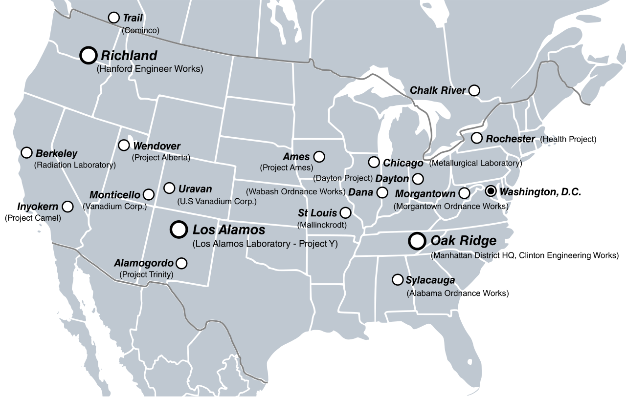
English: Major sites in the U.S. and Canada involved in the Manhattan Project. |
| Data | |
| Fonte |
Trabayu propiu
|
| Autor | Fallschirmjäger |
| Otres versiones | File:Manhattan Project US Map.png |

Llicencia
Yo, el titular de los drechos d'autor d'esta obra, la espublizo baxo la siguiente llicencia:
Esti ficheru ta disponible baxo la llicencia Creative Commons Reconocimientu-Compartir igual 3.0 xenérica.
- Ye llibre:
- pa compartir – pa copiar, distribuir y comunicar públicamente la obra
- pa remezclar – p'adautar la obra
- Baxo les condiciones siguientes:
- reconocimientu – Tienes de dar el créitu apropiáu, apurrir un enllaz a la llicencia ya indicar si realizasti dalgún cambéu. Puedes faelo de cualquier mou razonable ,pero non de manera que suxera l'encontu del autor pa ti o pal usu que faigas.
- compartir igual – Si entemeces, tresformes o te bases nesti material, tienes de distribuir les tos contribuciones baxo la mesma llicencia o una compatible cola orixinal.
Historial del ficheru
Calca nuna fecha/hora pa ver el ficheru como taba daquella.
| Data/Hora | Miniatura | Dimensiones | Usuariu | Comentariu | |
|---|---|---|---|---|---|
| actual | 12:52 20 xnt 2011 | | 1212 × 770 (305 kB) | Liandrei | Added more sites & Mexico |
| 12:56 1 xnt 2011 |  | 1212 × 770 (199 kB) | Liandrei | {{Information |Description={{en|Major sites in the U.S. and Canada involved in the Manhattan Project.}} |Source={{own}} *Base map from: File:BlankMap-USA-states-Canada-provinces, HI closer.svg |Date=2011-06-30 |Author= [[Use |
Usu del ficheru
La páxina siguiente usa esti ficheru:
Usu global del ficheru
Estes otres wikis usen esti ficheru:
- Usu en af.wikipedia.org
- Usu en ca.wikipedia.org
- Usu en cs.wikipedia.org
- Usu en da.wikipedia.org
- Usu en en.wikipedia.org
- Manhattan Project
- Talk:List of National Natural Landmarks in Michigan
- User:Pahazzard/sandbox
- Wikipedia:Graphics Lab/Illustration workshop/Archive/Jul 2011
- Wikipedia:Featured picture candidates/July-2011
- Wikipedia:Featured picture candidates/Manhattan Project clickable site map
- User:Arlene.crabtree/sandbox
- Usu en fr.wikipedia.org
- Usu en ga.wikipedia.org
- Usu en he.wikipedia.org
- Usu en hi.wikipedia.org
- Usu en hu.wikipedia.org
- Usu en ja.wikipedia.org
- Usu en no.wikipedia.org
- Usu en pt.wikipedia.org
- Usu en ro.wikipedia.org
- Usu en ru.wikipedia.org
- Usu en tt.wikipedia.org
- Usu en vi.wikipedia.org
- Usu en www.wikidata.org