Ficheru:Morrison Formation Brachiosauridae map.png

Tamañu d'esta previsualización: 627 × 600 pixels. Otres resoluciones: 251 × 240 pixels | 502 × 480 pixels | 803 × 768 pixels | 1071 × 1024 pixels | 2540 × 2429 pixels.
Ficheru orixinal (2540 × 2429 píxels, tamañu de ficheru: 73 kB, triba MIME: image/png)
Resume
| Descripción |
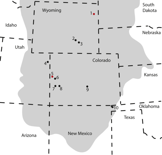
Map of occurrences of Brachiosauridae in the Upper Jurassic Morrison Formation. The locality of the pes described herein (1) and the type locality of Brachiosaurus altithorax (5) are highlighted in red. The gray area indicates the distribution of the Morrison Formation. 1, Bobcat Pit, Weston County, WY; 2, Freezeout Hills general, Carbon Co., WY; 3, Reed’s Quarry 13, Albany Co., WY; 4, Jensen/Jensen Quarry, Uintah Co., UT; 5, Fruita Paleontological Area general, Mesa Co., CO; 6, Riggs Quarry 13, Mesa Co., CO; 7, Dry Mesa Quarry, Mesa Co., CO; 8, Potter Creek Quarry, Montrose Co., CO; 9, Felch Quarry 1, Fremont Co., CO; 10, Kenton Pit 1, Cimarron Co., OK. Modified from Bonnan & Wedel (2004: fig. 2). |
| Data | |
| Fonte | https://peerj.com/articles/5250/ |
| Autor | Anthony Maltese, Emanuel Tschopp, Femke Holwerda, David Burnham |
| Permisu (Cómo reutilizar esti ficheru) |
https://peerj.com/articles/5250.pdf |
Llicencia
Este archivo está disponible bajo la licencia Creative Commons Atribución 4.0 Internacional.
- Ye llibre:
- pa compartir – pa copiar, distribuir y comunicar públicamente la obra
- pa remezclar – p'adautar la obra
- Baxo les condiciones siguientes:
- reconocimientu – Tienes de dar el créitu apropiáu, apurrir un enllaz a la llicencia ya indicar si realizasti dalgún cambéu. Puedes faelo de cualquier mou razonable ,pero non de manera que suxera l'encontu del autor pa ti o pal usu que faigas.
Este archivo, el cual fue publicado originalmente en https://peerj.com/articles/5250/, fue revisado el 24 July 2018 por el revisor Guanaco, quien confirmó que en esa fecha estaba disponible bajo la licencia indicada.
|
Historial del ficheru
Calca nuna fecha/hora pa ver el ficheru como taba daquella.
| Data/Hora | Miniatura | Dimensiones | Usuariu | Comentariu | |
|---|---|---|---|---|---|
| actual | 17:09 10 ago 2018 | | 2540 × 2429 (73 kB) | HerrAdams | Cropped 1 % horizontally, 1 % vertically using CropTool with precise mode. Removed border. |
| 20:17 24 xnt 2018 |  | 2571 × 2460 (111 kB) | FunkMonk | == {{int:filedesc}} == {{Information |description=Map of occurrences of Brachiosauridae in the Upper Jurassic Morrison Formation. The locality of the pes described herein (1) and the type locality of Brachiosaurus altithorax (5) are highlighted in red. The gray area indicates the distribution of the Morrison Formation. 1, Bobcat Pit, Weston County, WY; 2, Freezeout Hills general, Carbon Co., WY; 3, Reed’s Quarry 13, Albany Co., WY; 4, Jensen/Jensen Quarry, Uintah Co., UT; 5, Fruita Paleontolo... |
Usu del ficheru
La páxina siguiente usa esti ficheru:
Usu global del ficheru
Estes otres wikis usen esti ficheru:
- Usu en ar.wikipedia.org
- Usu en bg.wikipedia.org
- Usu en ca.wikipedia.org
- Usu en cs.wikipedia.org
- Usu en en.wikipedia.org
- Usu en eu.wikipedia.org
- Usu en he.wikipedia.org
- Usu en hr.wikipedia.org
- Usu en hu.wikipedia.org
- Usu en mk.wikipedia.org
- Usu en nn.wikipedia.org
- Usu en pl.wikipedia.org
- Usu en sv.wikipedia.org
- Usu en tr.wikipedia.org
- Usu en www.wikidata.org
- Usu en zh.wikipedia.org