Ficheru:Polish and Lithuanian Conflict with Prussia. 1377-1435..png
Tamañu d'esta previsualización: 696 × 600 pixels. Otres resoluciones: 279 × 240 pixels | 557 × 480 pixels | 968 × 834 pixels.
Ficheru orixinal (968 × 834 píxels, tamañu de ficheru: 182 kB, triba MIME: image/png)
Resume
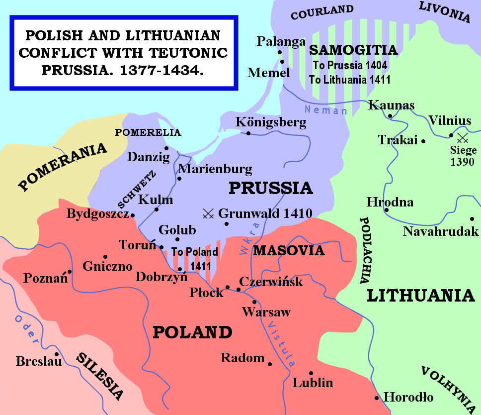
| Descripción | The map shows the areas of conflict between Teutonic Prussia and Poland and Lithuania during the reigns of Jogaila (Władysław II Jagiełło) and Vytautas. The areas on the borders of Prussia and Poland were particularly disputed: towns often changed hands, and Dobrzyń Land (red-and-mauve stripes) was passed back and forward as a result of various deals, treaties, and battles. Samogitia (green-and-mauve stripes) was also strongly disputed between the Teutonic Order and Lithuania, because the Knights wished to link up with the Livonian Lands further north. After the Battle of Grunwald in 1410, a series of treaties established Polish control over Dobrzyń Land and Lithuanian control over Samogitia for good, marking the beginning of the Teutonic State's decline. |
| Data | 29 de xineru de 2007 (fecha original de carga) |
| Fonte | No machine-readable source provided. Own work assumed (based on copyright claims). |
| Autor | No machine-readable author provided. Qp10qp assumed (based on copyright claims). |
Sources
- The map was outlined from this old German map: Image:Poland under Jagello.jpg.
Other references:
- The Times Concise Atlas of World History, Times Books, 1994, ISBN 0-7230-0674-1, p. 56.
- Lukowski, Jerzy and Hubert Zawadzki (2001). A Concise History of Poland. Cambridge: Cambridge University Press. ISBN 0-521-55917-0. Maps on p. 36-38.
- "Baltic Europe", in The New Cambridge Medieval History VI, ed. Michael Jones, Cambridge University Press, ISBN 0-521-36290-3. Map on p. 700.
Llicencia
| Yo, el titular de los drechos d'autor d'esta obra, la llibero como dominiu públicu. Esto s'aplica nel mundu ensembre. En dellos países seique esto nun seya posible llegalmente; nesti casu: Doi a cualesquier persona permisu pa usar esta obra pa cualesquier propósitu, ensin denguna condición, menos si eses condiciones requierense pola llei. |
Historial del ficheru
Calca nuna fecha/hora pa ver el ficheru como taba daquella.
| Data/Hora | Miniatura | Dimensiones | Usuariu | Comentariu | |
|---|---|---|---|---|---|
| actual | 23:22 14 feb 2007 | | 968 × 834 (182 kB) | Qp10qp | |
| 07:05 29 xin 2007 |  | 968 × 834 (182 kB) | Qp10qp | The map shows the areas of conflict between Teutonic Prussia and Poland and Lithuania during the reigns of Jogaila (Władysław II Jagiełło) and Vytautas. The areas on the borders of Prussia and Poland were particularly disputed: towns changed often cha |
Usu del ficheru
La páxina siguiente usa esti ficheru:
Usu global del ficheru
Estes otres wikis usen esti ficheru:
- Usu en ar.wikipedia.org
- Usu en az.wikipedia.org
- Usu en da.wikipedia.org
- Usu en en.wikipedia.org
- Usu en es.wikipedia.org
- Usu en fr.wikipedia.org
- Usu en gl.wikipedia.org
- Usu en he.wikipedia.org
- Usu en hu.wikipedia.org
- Usu en id.wikipedia.org
- Usu en it.wikipedia.org
- Usu en ja.wikipedia.org
- Usu en lt.wikibooks.org
- Usu en pl.wikipedia.org
- Usu en pt.wikipedia.org
- Usu en sl.wikipedia.org
- Usu en tr.wikipedia.org
- Usu en uk.wikipedia.org
- Usu en vls.wikipedia.org
- Usu en www.wikidata.org
- Usu en zh.wikipedia.org