Ficheru:Çanakkale districts.png

Tamañu d'esta previsualización: 776 × 600 pixels. Otres resoluciones: 311 × 240 pixels | 621 × 480 pixels | 994 × 768 pixels | 1056 × 816 pixels.
Ficheru orixinal (1056 × 816 píxels, tamañu de ficheru: 43 kB, triba MIME: image/png)
Resume
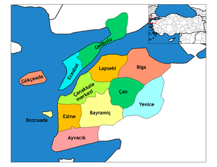
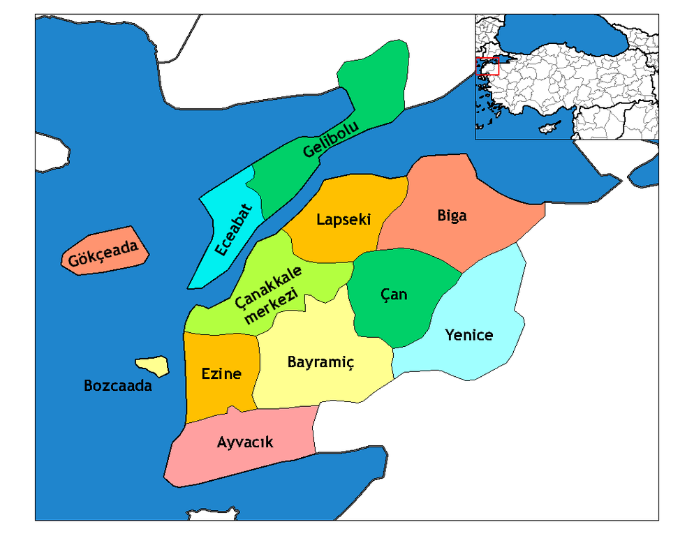
| Descripción | Map of the districts of Canakkale province in Turkey. Created by Rarelibra 19:28, 1 December 2006 (UTC) for public domain use, using MapInfo Professional v8.5 and various mapping resources. Edited by One Homo Sapiens Corrected text where İ,Ş,ı,ğ,or ş occurs in name. Source: [statoids-com]. Increased font size and enhanced color differences among adjacent districts. |
| Data | 31 de marzu de 2007 (fecha original de carga) |
| Fonte | No machine-readable source provided. Own work assumed (based on copyright claims). |
| Autor | No machine-readable author provided. Denizz~commonswiki assumed (based on copyright claims). |
Llicencia
| Yo, el titular de los drechos d'autor d'esta obra, la llibero como dominiu públicu. Esto s'aplica nel mundu ensembre. En dellos países seique esto nun seya posible llegalmente; nesti casu: Doi a cualesquier persona permisu pa usar esta obra pa cualesquier propósitu, ensin denguna condición, menos si eses condiciones requierense pola llei. |
Historial del ficheru
Calca nuna fecha/hora pa ver el ficheru como taba daquella.
| Data/Hora | Miniatura | Dimensiones | Usuariu | Comentariu | |
|---|---|---|---|---|---|
| actual | 04:22 29 avi 2008 | | 1056 × 816 (43 kB) | One Homo Sapiens | Corrected text where İ,Ş,ı,ğ,or ş occurs in name. Source: [statoids-com]. Increased font size and enhanced color differences among adjacent districts. |
| 15:47 12 abr 2007 |  | 776 × 600 (110 kB) | KureCewlik81 | ||
| 07:01 31 mar 2007 |  | 1056 × 816 (33 kB) | Denizz~commonswiki | == Summary == Map of the districts of Canakkale province in Turkey. Created by Rarelibra 19:28, 1 December 2006 (UTC) for public domain use, using MapInfo Professional v8.5 and various mapping resources. == Licensing == {{PD-self}} <!- |
Usu del ficheru
Les páxines siguientes usen esti ficheru:
Usu global del ficheru
Estes otres wikis usen esti ficheru:
- Usu en azb.wikipedia.org
- Usu en ba.wikipedia.org
- Usu en bg.wikipedia.org
- Usu en ca.wikipedia.org
- Usu en ceb.wikipedia.org
- Usu en ce.wikipedia.org
- Usu en cs.wikipedia.org
- Usu en de.wikipedia.org
- Usu en diq.wikipedia.org
- Usu en el.wikipedia.org
- Usu en en.wikipedia.org
- Imbros
- Çanakkale Province
- User talk:Rarelibra/Maps4
- Gökçeada District
- List of populated places in Çanakkale Province
- Districts of Turkey
- Akbaş arms depot raid
- Bozcaada, Çanakkale
- Governor of Çanakkale
- Gelibolu District
- Ayvacık District, Çanakkale
- Bayramiç District
- Biga District
- Çan District
- Çanakkale District
- Eceabat District
- Ezine District
- Lapseki District
- Yenice District, Çanakkale
- Usu en en.wiktionary.org
Ver más usos globales d'esti ficheru.