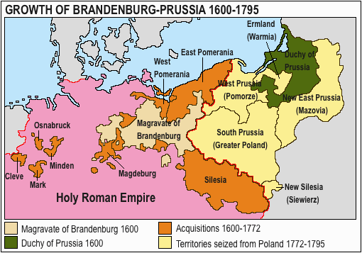
Ficheru:Acprussiamap2.gif
Nun ta disponible con mayor resolución.
Acprussiamap2.gif (510 × 357 píxels, tamañu de ficheru: 27 kB, triba MIME: image/gif, 0,1s)

This image was copied from wikipedia:pt. The original description was:
Licença GNU, fonte en:Wikipedia.

|
Autorízase la copia, distribución y/o cambéu d'esti documentu baxo los términos de la Llicencia de documentación llibre GNU, versión 1.2 o cualesquier otra que nel futuru espublice la Free Software Foundation; ensin seiciones invariables, testos de portada, nin testos de contraportada. S'inclúi una copia de la llicencia na seición titulada GNU Free Documentation License. |
| Esti ficheru ta disponible baxo la llicencia Creative Commons Reconocimientu-Compartir igual 3.0 xenérica. | ||
| ||
| Esta etiqueta de llicencia s'amestó a esti ficheru como parte del anovamientu de la llicencia GFDL. |

|
This map has been uploaded by Electionworld from en.wikipedia.org to enable the |
Growth of Prussia en:Image:Ac.prussiamap2.gif

|
Esta imagen debería volverse a crear como imágenes vectoriales SVG. Esto proporciona muchas ventajas, véase Commons:Media for cleanup (en inglés) para más información. Si ya hay una versión SVG de esta imagen disponible, por favor súbala a Commons. Tras subirla, reemplace esta plantilla con la plantilla
{{vector version available|nuevo nombre de imagen.svg}} en esta imagen. |
Historial del ficheru
Calca nuna fecha/hora pa ver el ficheru como taba daquella.
| Data/Hora | Miniatura | Dimensiones | Usuariu | Comentariu | |
|---|---|---|---|---|---|
| actual | 13:17 15 mar 2020 | | 510 × 357 (27 kB) | E-960 | Ermland, correction. |
| 12:50 15 mar 2020 |  | 510 × 357 (27 kB) | E-960 | Names of territories and format. | |
| 19:44 1 xun 2009 |  | 510 × 357 (14 kB) | Hohum | Changed colours to more cartographic, less garish. Made sea blue instead of portions of land. | |
| 18:36 25 ago 2006 |  | 510 × 357 (15 kB) | LeonardoG | This image was copied from wikipedia:pt. The original description was: Licença GNU, fonte en:Wikipedia. {{GFDL}} en:Image:Ac.prussiamap2.gif {| border="1" ! date/time || username || resolution || size || edit summary |---- | |} |
Usu del ficheru
Les páxines siguientes usen esti ficheru:
Usu global del ficheru
Estes otres wikis usen esti ficheru:
- Usu en af.wikipedia.org
- Usu en ar.wikipedia.org
- Usu en bg.wikipedia.org
- Usu en ca.wikipedia.org
- Usu en cs.wikipedia.org
- Usu en el.wikipedia.org
- Usu en en.wikipedia.org
- History of Germany
- House of Hohenzollern
- Prussia
- Margraviate of Brandenburg
- Prussian Army
- Territorial evolution of Germany
- Subdivisions of the Polish–Lithuanian territories following the partitions
- Prussian Partition
- 18th-century history of Germany
- Brandenburg–Pomeranian conflict
- Treaty of Vossem (1673)
- User:Falcaorib
- User:JMvanDijk/Sandbox 9/Box 15/Box 3
- Usu en es.wikipedia.org
- Usu en et.wikipedia.org
- Usu en eu.wikipedia.org
- Usu en fa.wikipedia.org
- Usu en fi.wikipedia.org
- Usu en fr.wikipedia.org
- Usu en he.wikipedia.org
- Usu en hy.wikipedia.org
- Usu en it.wikipedia.org
Ver más usos globales d'esti ficheru.