Ficheru:Arctic Ocean bathymetric features.png

Tamañu d'esta previsualización: 725 × 600 pixels. Otres resoluciones: 290 × 240 pixels | 581 × 480 pixels | 803 × 664 pixels.
Ficheru orixinal (803 × 664 píxels, tamañu de ficheru: 664 kB, triba MIME: image/png)
Resume
| Descripción |
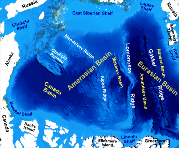
English: Main bathymetric features of the Arctic Ocean, taken mainly from Weber 1983 'Maps of the Arctic Basin Sea Floor: A History of Bathymetry and its Interpretation' on a base of a screenshot taken from the NASA WorldWind software |
| Data | |
| Fonte | Trabayu propiu |
| Autor | Mikenorton |
Llicencia
Yo, el titular de los drechos d'autor d'esta obra, la espublizo baxo la siguiente llicencia:
Esti ficheru ta disponible baxo la llicencia Creative Commons Reconocimientu-Compartir igual 3.0 xenérica.
- Ye llibre:
- pa compartir – pa copiar, distribuir y comunicar públicamente la obra
- pa remezclar – p'adautar la obra
- Baxo les condiciones siguientes:
- reconocimientu – Tienes de dar el créitu apropiáu, apurrir un enllaz a la llicencia ya indicar si realizasti dalgún cambéu. Puedes faelo de cualquier mou razonable ,pero non de manera que suxera l'encontu del autor pa ti o pal usu que faigas.
- compartir igual – Si entemeces, tresformes o te bases nesti material, tienes de distribuir les tos contribuciones baxo la mesma llicencia o una compatible cola orixinal.
Historial del ficheru
Calca nuna fecha/hora pa ver el ficheru como taba daquella.
| Data/Hora | Miniatura | Dimensiones | Usuariu | Comentariu | |
|---|---|---|---|---|---|
| actual | 00:12 10 pay 2012 | | 803 × 664 (664 kB) | Mikenorton | The 'Fram Basin' is now known as the 'Amundsen Basin' and the location of the two basins either side of the Gakkel Ridge has now been corrected |
| 11:21 2 och 2011 |  | 2408 × 1993 (1,42 MB) | Mikenorton |
Usu del ficheru
Nun hai páxines qu'usen esti ficheru.
Usu global del ficheru
Estes otres wikis usen esti ficheru:
- Usu en ar.wikipedia.org
- Usu en az.wikipedia.org
- Usu en be.wikipedia.org
- Usu en ca.wikipedia.org
- Usu en cs.wikipedia.org
- Usu en de.wikipedia.org
- Usu en en.wikipedia.org
- Gakkel Ridge
- Lomonosov Ridge
- Litke Deep
- Mendeleev Ridge
- Alpha Ridge
- Siberian Shelf
- Eurasian Basin
- Amerasia Basin
- Chukchi Shelf
- Arctic Basin
- Arctic policy of Canada
- Talk:Arctic policy of Canada
- Canada Basin
- Makarov Basin
- Template:Did you know nominations/Geology of the Pacific Ocean
- Chukchi Plateau
- Gakkel Ridge Caldera
- Usu en en.wikiversity.org
- Usu en eo.wikipedia.org
- Usu en es.wikipedia.org
- Usu en fa.wikipedia.org
Ver más usos globales d'esti ficheru.