Ficheru:Barentsz Full Map.jpg

Tamañu d'esta previsualización: 800 × 594 pixels. Otres resoluciones: 320 × 237 pixels | 640 × 475 pixels | 1000 × 742 pixels.
Ficheru orixinal (1000 × 742 píxels, tamañu de ficheru: 258 kB, triba MIME: image/jpeg)
Resume
| Descripción |
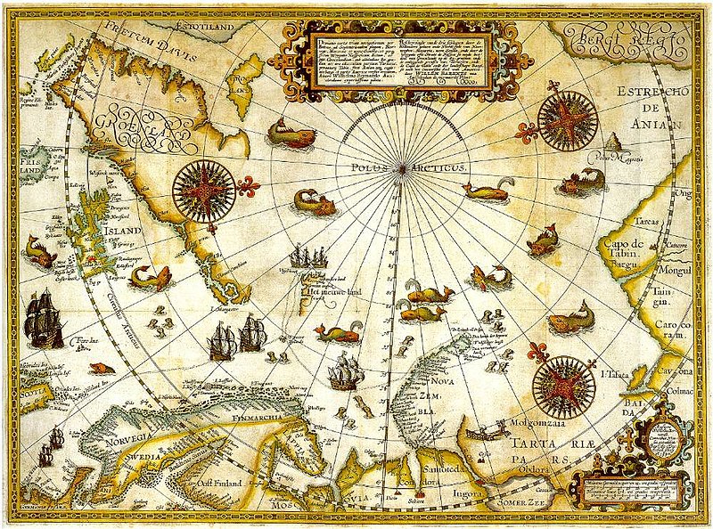
1598 map of the hree Arctic voyages (1594–1596) by Willem Barentsz. Delineatio cartae trium navigantium per Bataves, ad Septentrionalem plagam, Norvegiae, Moscoviae et novae Semblae Autore Wilhelmo Bernardo [1] [2] |
| Data | |
| Fonte | immediate source unknown, uploaded 2007 |
| Autor | Willem Barentsz (Wilhelmus Bernardus) |
| Permisu (Cómo reutilizar esti ficheru) |
Public domain (over 70 years since creator's death) |
| Otres versiones |
|

.jpg)
_door_Willem_Barendsz_(titel_op_object),_NG-800.jpg)


Llicencia
|
Este material está en dominio público en los demás países donde el derecho de autor se extiende por 100 años (o menos) tras la muerte del autor. | |
| Esta obra ha sido identificada como libre de las restricciones conocidas en virtud del derecho de autor, incluyendo todos los derechos conexos. | |
Historial del ficheru
Calca nuna fecha/hora pa ver el ficheru como taba daquella.
| Data/Hora | Miniatura | Dimensiones | Usuariu | Comentariu | |
|---|---|---|---|---|---|
| actual | 22:20 5 avi 2007 | | 1000 × 742 (258 kB) | Sherurcij | {{Information |Description=Portion of 1599 map of Arctic exploration by Willem Barentsz. Spitsbergen, here mapped for the first time, is indicated as "Het Nieuwe Land" (Dutch for "the New Land"), center-left. |Source=[http://www.ub.uit.no/northernlights/e |
Usu del ficheru
Nun hai páxines qu'usen esti ficheru.
Usu global del ficheru
Estes otres wikis usen esti ficheru:
- Usu en ar.wikipedia.org
- Usu en fr.wikipedia.org
- Usu en gcr.wikipedia.org
- Usu en kk.wikipedia.org
- Usu en nrm.wikipedia.org
- Usu en ru.wikipedia.org