Ficheru:Bgiusca Jirecek Line.jpg
Nun ta disponible con mayor resolución.
Bgiusca_Jirecek_Line.jpg (614 × 561 píxels, tamañu de ficheru: 176 kB, triba MIME: image/jpeg)
| Descripción |
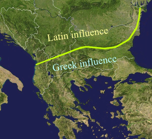
The Jirecek Line, which divides the kind of archaeological findings: to the north of the line most of the inscriptions are in Latin, to the south, they are in Greek. Aegyssos, Argamum, Histria, Tomis & Kallatis cities had greek and latin inscriptions until the VIIth cen. after JC. Jireček claimed that this line represents The division between the Greek and the Latin influence in the Balkans during the Roman Empire |
| Data | |
| Fonte | Public domain NASA image via worldwind |
| Autor | Bogdan Giuşcă |
| Permisu (Cómo reutilizar esti ficheru) |
GFDL |

|
Autorízase la copia, distribución y/o cambéu d'esti documentu baxo los términos de la Llicencia de documentación llibre GNU, versión 1.2 o cualesquier otra que nel futuru espublice la Free Software Foundation; ensin seiciones invariables, testos de portada, nin testos de contraportada. S'inclúi una copia de la llicencia na seición titulada GNU Free Documentation License. |
| Esti ficheru ta disponible baxo la llicencia Creative Commons Reconocimientu-Compartir igual 3.0 xenérica. | ||
| ||
| Esta etiqueta de llicencia s'amestó a esti ficheru como parte del anovamientu de la llicencia GFDL. |
Historial del ficheru
Calca nuna fecha/hora pa ver el ficheru como taba daquella.
| Data/Hora | Miniatura | Dimensiones | Usuariu | Comentariu | |
|---|---|---|---|---|---|
| actual | 01:27 23 feb 2022 | | 614 × 561 (176 kB) | Demetrios1993 | The initial version by User:Bogdan had it correct, but later, the western section of the line was altered without any justification. |
| 10:01 25 mar 2018 |  | 614 × 561 (249 kB) | Trecătorul răcit | Antic shoreline and correct present-day borders | |
| 10:50 7 ago 2014 |  | 614 × 561 (250 kB) | Spiridon Ion Cepleanu | According with Jirecek's works and the palaeography of Aegyssos, Argamum, Histria, Tomis & Kallatis cities (greek and latin inscriptions until the VIIth cen. after JC) | |
| 09:56 19 abr 2005 |  | 614 × 561 (101 kB) | Bogdan | The division between the Greek and the Latin influence in the Balkans during the Roman Empire Source: Public domain work {{GFDL}} Category:Romanian historyCategory:Roman Empire\ |
Usu del ficheru
La páxina siguiente usa esti ficheru:
Usu global del ficheru
Estes otres wikis usen esti ficheru:
- Usu en an.wikipedia.org
- Usu en ar.wikipedia.org
- Usu en ba.wikipedia.org
- Usu en bg.wikipedia.org
- Usu en ca.wikipedia.org
- Usu en ce.wikipedia.org
- Usu en cs.wikipedia.org
- Usu en cv.wikipedia.org
- Usu en de.wikipedia.org
- Usu en el.wikipedia.org
- Usu en en.wikipedia.org
- Usu en es.wikipedia.org
- Usu en et.wikipedia.org
- Usu en eu.wikipedia.org
- Usu en fa.wikipedia.org
- Usu en fr.wikipedia.org
- Usu en he.wikipedia.org
- Usu en hi.wikipedia.org
- Usu en hr.wikipedia.org
- Usu en id.wikipedia.org
- Usu en it.wikipedia.org
- Usu en ja.wikipedia.org
- Usu en ka.wikipedia.org
- Usu en ko.wikipedia.org
- Usu en la.wikipedia.org
- Usu en lt.wikipedia.org
- Usu en nl.wikipedia.org
- Usu en no.wikipedia.org
Ver más usos globales d'esti ficheru.