Ficheru:Europe 1848 map en.png

Tamañu d'esta previsualización: 800 × 526 pixels. Otres resoluciones: 320 × 211 pixels | 640 × 421 pixels | 1024 × 674 pixels | 1280 × 842 pixels | 2284 × 1503 pixels.
Ficheru orixinal (2284 × 1503 píxels, tamañu de ficheru: 1,22 MB, triba MIME: image/png)
Resume
| Descripción |
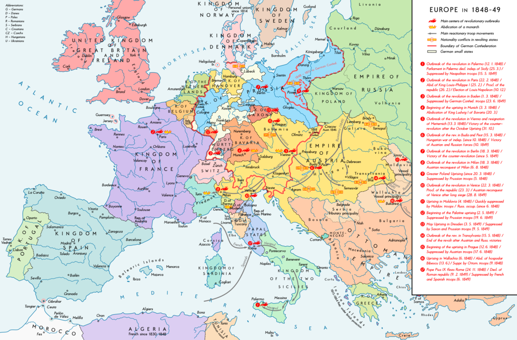
English: Europe 1848-49. Historical map with main revolutionary centres, important reactionary troop movements, states with abdications and national conflicts. Please don't alter the map, when you think there something not written or depicted correctly. Leave a message at the talk page of the file. After a verification and a possible discussion, i will upload a new map version with all new changes. This prevents an unnecessary waste of disc space and ensures a good result, aesthetically and contentwise. - The author. Deutsch: Europa 1848/49. Historische Karte mit wichtigen revolutionären Orten, Hauptschlagrichtungen konterrevolutionärer Truppen, Staaten mit Abdankungen von Monarchen und Nationalitätenkonflikten. Bitte die Karte bei Änderungs- und Korrekturwünschen nicht selbst verändern, sondern eine Anmerkung im Diskussionsbereich der Bilddatei hinterlassen. Nach einer Prüfung und ggfs. Diskussion werden evtl. Änderungen von mir zusammengefasst eingearbeitet. Das vermeidet unnötige Speicherplatz-Verschwendung und gewährleistet ein ästhetisch ansprechendes und inhaltlich korrektes Ergebnis. - Der Urheber. |
| Data | |
| Fonte |
Trabayu propiu. Source of Information: Historical atlases – Ramsay Muir, George Philip (ed.): Philip's New School Atlas of Universal History, George Philip & Son, Ltd., London 1928 – Dr. Walter Leisering (ed.): Putzger Historischer Weltatlas, Cornelsen Verlag, Berlin 1992, ISBN 3-464-00176-8 – Bayerischer Schulbuch-Verlag (ed.): Großer Historischer Weltatlas, Dritter Teil, Neuzeit, Bayerischer Schulbuch-Verlag, München 1981, ISBN 3-7627-6021-7 – Prof. Dr. Vadim Oswalt u. Prof. Dr. Hans Ulrich Rudolf (ed.): Klett-Perthes Atlas zur Weltgeschichte, Ernst Klett Verlag, Stuttgart 2011, ISBN 978-3-12-828194-0 – Zentralinstitut für Geschichte der Akademie der Wissenschaften der DDR (ed.): Atlas zur Geschichte, Band 1, VEB Hermann Haack, Gotha 1989, ISBN 3-7301-0040-8 – Domokos György (ed.): Történelmi atlasz a középiskolák számára, Kartográfiai Vállalat. Budapest, Budapest 1989, ISBN 963-351-422-3 Other publications – Mike Rapport: 1848. Revolution in Europa, Wissenschaftliche Buchgesellschaft, Lizenzausgabe des Konrad Theiss Verlags, 2011, ISBN 978-3-534-23963-4 |
| Autor | Alexander Altenhof |
| Otres versiones |
|


Recompressed without quality loss with OptiPNG (1.51 MB > 1.20 MB)
Llicencia
Yo, el titular de los drechos d'autor d'esta obra, la espublizo baxo la siguiente llicencia:
Este archivo está disponible bajo la licencia Creative Commons Atribución-CompartirIgual 4.0 Internacional.
- Ye llibre:
- pa compartir – pa copiar, distribuir y comunicar públicamente la obra
- pa remezclar – p'adautar la obra
- Baxo les condiciones siguientes:
- reconocimientu – Tienes de dar el créitu apropiáu, apurrir un enllaz a la llicencia ya indicar si realizasti dalgún cambéu. Puedes faelo de cualquier mou razonable ,pero non de manera que suxera l'encontu del autor pa ti o pal usu que faigas.
- compartir igual – Si entemeces, tresformes o te bases nesti material, tienes de distribuir les tos contribuciones baxo la mesma llicencia o una compatible cola orixinal.
Historial del ficheru
Calca nuna fecha/hora pa ver el ficheru como taba daquella.
| Data/Hora | Miniatura | Dimensiones | Usuariu | Comentariu | |
|---|---|---|---|---|---|
| actual | 23:38 14 abr 2017 | | 2284 × 1503 (1,22 MB) | KaterBegemot | Minor changes |
| 22:50 11 set 2016 |  | 2284 × 1503 (1,21 MB) | KaterBegemot | Changed border of Serbia | |
| 22:34 11 set 2016 |  | 2284 × 1503 (1,21 MB) | KaterBegemot | Changed color of Greece, corrected border at Tarnopol, minor text corrections | |
| 15:17 29 ago 2016 |  | 2284 × 1503 (1,21 MB) | KaterBegemot | {{Information |Description ={{en|1=Europe 1848-49. Historical map with main revolutionary centres, important reactionary troop movements, states with abdications and national conflicts.<br> ''Please don't alter the map, when you think there somethin... |
Usu del ficheru
La páxina siguiente usa esti ficheru:
Usu global del ficheru
Estes otres wikis usen esti ficheru:
- Usu en ar.wikipedia.org
- Usu en az.wikipedia.org
- Usu en el.wikipedia.org
- Usu en en.wikipedia.org
- Usu en he.wikipedia.org
- Usu en hr.wikipedia.org
- Usu en hu.wikipedia.org
- Usu en it.wikipedia.org
- Usu en ja.wikipedia.org
- Usu en ka.wikipedia.org
- Usu en km.wikipedia.org
- Usu en lt.wikipedia.org
- Usu en mk.wikipedia.org
- Usu en pnb.wikipedia.org
- Usu en ru.wikipedia.org
- Usu en sq.wikipedia.org
- Usu en uk.wikipedia.org
- Usu en ur.wikipedia.org
- Usu en vi.wikipedia.org