Ficheru:FEMA - 12091 - Photograph by FEMA ITS Mapping and Analysis taken on 11-04-2004 in District of Columbia.jpg

Tamañu d'esta previsualización: 463 × 599 pixels. Otres resoluciones: 185 × 240 pixels | 371 × 480 pixels | 593 × 768 pixels | 1275 × 1650 pixels.
Ficheru orixinal (1275 × 1650 píxels, tamañu de ficheru: 611 kB, triba MIME: image/jpeg)
Resume
| Descripción |
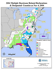
English: Washington, DC, November 4, 2004 -- This is an illustration of the 2004 Multiple Hurricane Related Declarations and Designated counties as of Nov. 4, 2004. FEMA ITS Mapping and Analysis Center |
| Data | |
| Fonte |
This image is from the FEMA Photo Library (obsolete as of 2019). An archived copy may be found at the Wayback Machine (note: link may be permanently dead, as not all photos were backed up in this way). If the FEMA link is permanently dead, the photo can be found at NARA Access to Archival Databases (only works if photo was taken between 1989 and October 2004), or at City-data.com. |
| Autor | FEMA ITS Mapping and Analysis |
Llicencia
This image is a work of a Federal Emergency Management Agency employee, taken or made as part of that person's official duties. As works of the U.S. federal government, all FEMA images are in the public domain in the United States. Additional media usage information may be found at https://www.fema.gov/photo-video-audio-use-guidelines
|
Historial del ficheru
Calca nuna fecha/hora pa ver el ficheru como taba daquella.
| Data/Hora | Miniatura | Dimensiones | Usuariu | Comentariu | |
|---|---|---|---|---|---|
| actual | 10:21 15 och 2009 | | 1275 × 1650 (611 kB) | BotMultichillT | == {{int:filedesc}} == {{Information |description={{en|1=Washington, DC, November 4, 2004 -- This is an illustration of the 2004 Multiple Hurricane Related Declarations and Designated counties as of Nov. 4, 2004. FEMA ITS Mapping and Analysis Center}} |d |
Usu del ficheru
La páxina siguiente usa esti ficheru:
Usu global del ficheru
Estes otres wikis usen esti ficheru:
- Usu en en.wikipedia.org
- Usu en es.wikipedia.org