Ficheru:German Empire states map.svg

Tamañu de la vista previa PNG d'esti ficheru SVG: 496 × 600 pixels. Otres resoluciones: 198 × 240 pixels | 397 × 480 pixels | 635 × 768 pixels | 847 × 1024 pixels | 1694 × 2048 pixels | 1042 × 1260 pixels.
Ficheru orixinal (ficheru SVG, 1042 × 1260 píxels nominales, tamañu de ficheru: 2,31 MB)
Resume
| Descripción |
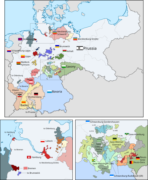
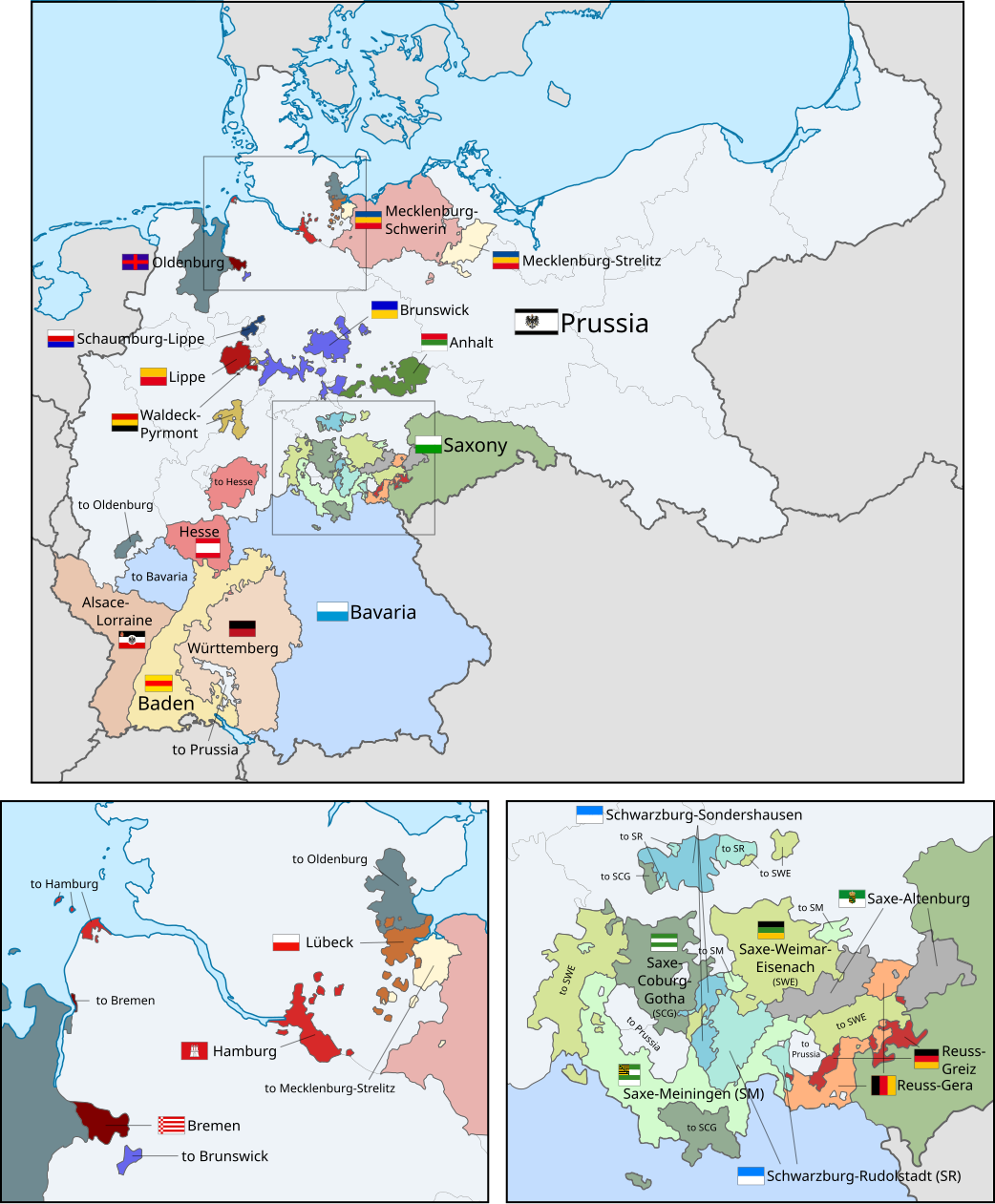
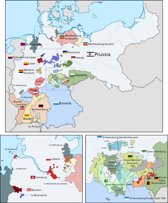
English: A map of the states of the German Empire, showing their location, flags and names in English. |
| Data | |
| Fonte |
Este archivo deriva de: German Empire blank map.svg: Esta imagen vectorial incluye elementos que han sido tomados o adaptados de esta: Esta imagen vectorial incluye elementos que han sido tomados o adaptados de esta: Esta imagen vectorial incluye elementos que han sido tomados o adaptados de esta: Esta imagen vectorial incluye elementos que han sido tomados o adaptados de esta: Esta imagen vectorial incluye elementos que han sido tomados o adaptados de esta: Esta imagen vectorial incluye elementos que han sido tomados o adaptados de esta: Esta imagen vectorial incluye elementos que han sido tomados o adaptados de esta: Esta imagen vectorial incluye elementos que han sido tomados o adaptados de esta: Esta imagen vectorial incluye elementos que han sido tomados o adaptados de esta: Esta imagen vectorial incluye elementos que han sido tomados o adaptados de esta: Esta imagen vectorial incluye elementos que han sido tomados o adaptados de esta: Esta imagen vectorial incluye elementos que han sido tomados o adaptados de esta: Esta imagen vectorial incluye elementos que han sido tomados o adaptados de esta: Esta imagen vectorial incluye elementos que han sido tomados o adaptados de esta: Esta imagen vectorial incluye elementos que han sido tomados o adaptados de esta: Esta imagen vectorial incluye elementos que han sido tomados o adaptados de esta: Esta imagen vectorial incluye elementos que han sido tomados o adaptados de esta: Esta imagen vectorial incluye elementos que han sido tomados o adaptados de esta: Esta imagen vectorial incluye elementos que han sido tomados o adaptados de esta: Esta imagen vectorial incluye elementos que han sido tomados o adaptados de esta: Esta imagen vectorial incluye elementos que han sido tomados o adaptados de esta: Esta imagen vectorial incluye elementos que han sido tomados o adaptados de esta: Esta imagen vectorial incluye elementos que han sido tomados o adaptados de esta: Esta imagen incluye elementos que han sido tomados o adaptados de esta: |
| Autor |
|
| Otres versiones |
|
| SVG desarrollo | El código fuente de esta imagen SVG es válido. Esta bandera fue creada con una desconocida SVG herramienta This flag uses embedded text that can be easily translated using a text editor. |


.svg)
.svg)
.svg)
.svg)
.svg)
.svg)
Llicencia
Yo, el titular de los drechos d'autor d'esta obra, la espublizo baxo la siguiente llicencia:
Esti ficheru ta disponible baxo la llicencia Creative Commons Reconocimientu-Compartir igual 3.0 xenérica.
- Ye llibre:
- pa compartir – pa copiar, distribuir y comunicar públicamente la obra
- pa remezclar – p'adautar la obra
- Baxo les condiciones siguientes:
- reconocimientu – Tienes de dar el créitu apropiáu, apurrir un enllaz a la llicencia ya indicar si realizasti dalgún cambéu. Puedes faelo de cualquier mou razonable ,pero non de manera que suxera l'encontu del autor pa ti o pal usu que faigas.
- compartir igual – Si entemeces, tresformes o te bases nesti material, tienes de distribuir les tos contribuciones baxo la mesma llicencia o una compatible cola orixinal.
Code for clickable map
Historial del ficheru
Calca nuna fecha/hora pa ver el ficheru como taba daquella.
| Data/Hora | Miniatura | Dimensiones | Usuariu | Comentariu | |
|---|---|---|---|---|---|
| actual | 02:43 24 feb 2019 | | 1042 × 1260 (2,31 MB) | Alphathon | Corrected Brunswick territory accidentally given to Anhalt |
| 14:55 4 pay 2015 |  | 1042 × 1260 (2,39 MB) | Alphathon | Slight optimisation | |
| 01:33 4 pay 2015 |  | 1042 × 1260 (2,39 MB) | Alphathon | Another minor tweak | |
| 01:31 4 pay 2015 |  | 1042 × 1260 (2,39 MB) | Alphathon | Tweaked colours | |
| 22:25 3 pay 2015 |  | 1042 × 1260 (2,39 MB) | Alphathon | Corrected typo | |
| 11:51 3 pay 2015 |  | 1042 × 1260 (2,39 MB) | Alphathon | {{Information |Description={{en|A map of the states of the en:German Empire, showing their location, flags and names in English.}} |Source={{Derived from|File:German Empire blank map.svg|display=50}} {{AttribSVG|Flagge Herzogtum Anhalt.svg|David... |
Usu del ficheru
La páxina siguiente usa esti ficheru:
Usu global del ficheru
Estes otres wikis usen esti ficheru:
- Usu en ar.wikipedia.org
- Usu en az.wikipedia.org
- Usu en ca.wikipedia.org
- Usu en en.wikipedia.org
- Usu en es.wikipedia.org
- Usu en fi.wikipedia.org
- Usu en he.wikipedia.org
- Usu en hu.wikipedia.org
- Usu en it.wikipedia.org
- Usu en nl.wikipedia.org
- Usu en pt.wikipedia.org
- Usu en sr.wikipedia.org
- Usu en th.wikipedia.org
- Usu en zh.wikipedia.org