Ficheru:GiantsCastlePanoramaSmall.jpg
Tamañu d'esta previsualización: 800 × 110 pixels. Otres resoluciones: 320 × 44 pixels | 640 × 88 pixels | 4000 × 548 pixels.
Ficheru orixinal (4000 × 548 píxels, tamañu de ficheru: 1,4 MB, triba MIME: image/jpeg)
Resume
| Descripción |
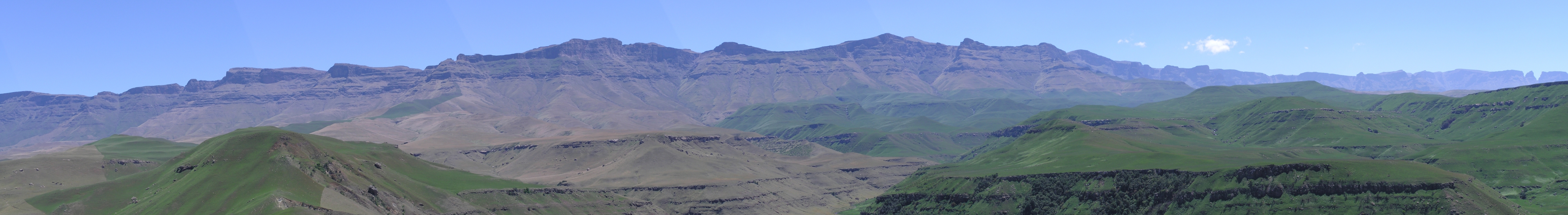
L: 29°20′07″S 29°27′19″E / 29.33528°S 29.45528°E R: 29°04′29″S 29°21′04″E / 29.07472°S 29.35111°E Afrikaans: Panorama van die KwaZulu-Natalse Drakensberg, van die nabye van Giant's Castle, heel links en net buite sig, tot by Cathkinpiek heel regs, 'n direkte afstand van 31 km.
English: Panorama of the KwaZulu-Natal Drakensberg, from the vicinity of Giant's Castle, on left and just out of sight, through to Cathkin Peak at far right, a direct distance of 31 kilometres (19 mi).
Deutsch: Panorama am Giant's Castle, Drakensberge, Südafrika. |
| Data | hacia 2005 |
| Fonte | Trabayu propiu |
| Autor | KlausF |
Llicencia

|
Autorízase la copia, distribución y/o cambéu d'esti documentu baxo los términos de la Llicencia de documentación llibre GNU, versión 1.2 o cualesquier otra que nel futuru espublice la Free Software Foundation; ensin seiciones invariables, testos de portada, nin testos de contraportada. S'inclúi una copia de la llicencia na seición titulada GNU Free Documentation License. |
| Esti ficheru ta disponible baxo la llicencia Creative Commons Reconocimientu-Compartir igual 3.0 xenérica. | ||
| ||
| Esta etiqueta de llicencia s'amestó a esti ficheru como parte del anovamientu de la llicencia GFDL. |
Historial del ficheru
Calca nuna fecha/hora pa ver el ficheru como taba daquella.
| Data/Hora | Miniatura | Dimensiones | Usuariu | Comentariu | |
|---|---|---|---|---|---|
| actual | 08:17 13 may 2005 | 4000 × 548 (1,4 MB) | KlausF | Panorama am Giant's Castle, Drakensberge, Südafrika {{GFDL}} |
Usu del ficheru
La páxina siguiente usa esti ficheru:
Usu global del ficheru
Estes otres wikis usen esti ficheru:
- Usu en af.wikipedia.org
- Usu en bg.wikipedia.org
- Usu en bn.wikipedia.org
- Usu en ca.wikipedia.org
- Usu en da.wikipedia.org
- Usu en de.wikipedia.org
- Usu en el.wikipedia.org
- Usu en en.wikipedia.org
- Usu en en.wikivoyage.org
- Usu en eo.wikipedia.org
- Usu en es.wikipedia.org
- Usu en fr.wikipedia.org
- Usu en he.wikipedia.org
- Usu en hr.wikipedia.org
- Usu en hy.wikipedia.org
- Usu en id.wikipedia.org
- Usu en it.wikipedia.org
- Usu en it.wikivoyage.org
- Usu en ja.wikipedia.org
- Usu en ka.wikipedia.org
- Usu en ko.wikipedia.org
- Usu en ky.wikipedia.org
- Usu en nn.wikipedia.org
- Usu en no.wikipedia.org
- Usu en pl.wikipedia.org
- Usu en pt.wikipedia.org
- Usu en sh.wikipedia.org
- Usu en sk.wikipedia.org
- Usu en sr.wikipedia.org
- Usu en sv.wikipedia.org
- Usu en uk.wikipedia.org
- Usu en vi.wikipedia.org
- Usu en www.wikidata.org
- Usu en zu.wikipedia.org