Ficheru:GisLayers.png

Tamañu d'esta previsualización: 800 × 527 pixels. Otres resoluciones: 320 × 211 pixels | 640 × 422 pixels | 997 × 657 pixels.
Ficheru orixinal (997 × 657 píxels, tamañu de ficheru: 1,39 MB, triba MIME: image/png)
Resume
| Descripción |
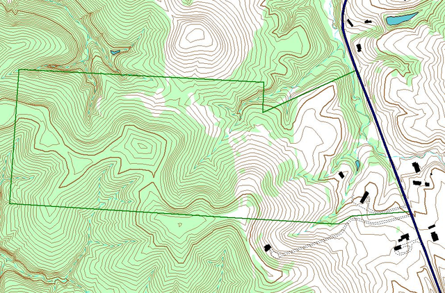
English: Example of layers used in GIS work. This map is of an Athens County, Ohio property, and was made using ArcView GIS 3.3, by John Knouse |
| Data | 8 de payares de 2007 (fecha original de carga) |
| Fonte | Transferido desde en.wikipedia a Commons. |
| Autor | Jaknouse de Wikipedia en inglés |
Llicencia
Jaknouse de Wikipedia en inglés, titular de los drechos d'autor d'esta obra, la espubliza baxo les siguientes llicencies:

|
Autorízase la copia, distribución y/o cambéu d'esti documentu baxo los términos de la Llicencia de documentación llibre GNU, versión 1.2 o cualesquier otra que nel futuru espublice la Free Software Foundation; ensin seiciones invariables, testos de portada, nin testos de contraportada. S'inclúi una copia de la llicencia na seición titulada GNU Free Documentation License. |
Este archivo se encuentra bajo la licencia Creative Commons Atribución 3.0 Unported.
Reconocimientu: Jaknouse de Wikipedia en inglés
- Ye llibre:
- pa compartir – pa copiar, distribuir y comunicar públicamente la obra
- pa remezclar – p'adautar la obra
- Baxo les condiciones siguientes:
- reconocimientu – Tienes de dar el créitu apropiáu, apurrir un enllaz a la llicencia ya indicar si realizasti dalgún cambéu. Puedes faelo de cualquier mou razonable ,pero non de manera que suxera l'encontu del autor pa ti o pal usu que faigas.
Pues seleicionar la llicencia que prefieras.
Rexistru de xubíes orixinal
Aquí se muestra la página de descripción original. Los siguientes nombres de usuario se refieren a en.wikipedia.
- 2007-11-08 23:37 Jaknouse 997×657× (307357 bytes) Example of layers used in GIS work. This map is of an Athens County, Ohio property, and was made using ArcView GIS 3.3, by John Knouse
Historial del ficheru
Calca nuna fecha/hora pa ver el ficheru como taba daquella.
| Data/Hora | Miniatura | Dimensiones | Usuariu | Comentariu | |
|---|---|---|---|---|---|
| actual | 14:02 19 och 2008 | | 997 × 657 (1,39 MB) | Tony Rotondas | {{Information |Description={{en|Example of layers used in GIS work. This map is of an Athens County, Ohio property, and was made using ArcView GIS 3.3, by John Knouse}} |Source=Transferred from [http://en.wikipedia.org en.wikipedia] |Date=2007-11-08 (ori |
Usu del ficheru
La páxina siguiente usa esti ficheru:
Usu global del ficheru
Estes otres wikis usen esti ficheru:
- Usu en es.wikipedia.org
- Usu en th.wikipedia.org