Ficheru:Greenland edcp relief location map.jpg

Tamañu d'esta previsualización: 424 × 599 pixels. Otres resoluciones: 170 × 240 pixels | 340 × 480 pixels | 543 × 768 pixels | 1181 × 1669 pixels.
Ficheru orixinal (1181 × 1669 píxels, tamañu de ficheru: 1,26 MB, triba MIME: image/jpeg)
Resume
| Descripción |
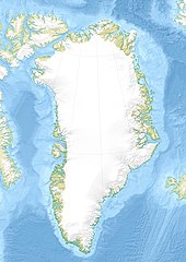
English: Relief location map of Greenland.
|
| Data | |
| Fonte | Trabayu propiu |
| Autor | Uwe Dedering |
| Otres versiones |
|


Llicencia
Yo, el titular de los drechos d'autor d'esta obra, la espublizo baxo les siguientes llicencies:
Esti ficheru ta disponible baxo la llicencia Creative Commons Reconocimientu-Compartir igual 3.0 xenérica.
- Ye llibre:
- pa compartir – pa copiar, distribuir y comunicar públicamente la obra
- pa remezclar – p'adautar la obra
- Baxo les condiciones siguientes:
- reconocimientu – Tienes de dar el créitu apropiáu, apurrir un enllaz a la llicencia ya indicar si realizasti dalgún cambéu. Puedes faelo de cualquier mou razonable ,pero non de manera que suxera l'encontu del autor pa ti o pal usu que faigas.
- compartir igual – Si entemeces, tresformes o te bases nesti material, tienes de distribuir les tos contribuciones baxo la mesma llicencia o una compatible cola orixinal.

|
Autorízase la copia, distribución y/o cambéu d'esti documentu baxo los términos de la Llicencia de documentación llibre GNU, versión 1.2 o cualesquier otra que nel futuru espublice la Free Software Foundation; ensin seiciones invariables, testos de portada, nin testos de contraportada. S'inclúi una copia de la llicencia na seición titulada GNU Free Documentation License. |
Pues seleicionar la llicencia que prefieras.
Historial del ficheru
Calca nuna fecha/hora pa ver el ficheru como taba daquella.
| Data/Hora | Miniatura | Dimensiones | Usuariu | Comentariu | |
|---|---|---|---|---|---|
| actual | 16:09 1 avi 2010 | | 1181 × 1669 (1,26 MB) | Uwe Dedering | {{Information |Description={{en|1= Relief location map of Greenland. * Projection: EquiDistantConicProjection. * Area of interest: :* N: 85.0° N :* S: 59.0° N :* W: -75.0° E :* E: -10.0° E * Projection center: :* NS: 72.0° N :* WE: -42.5° E *Standar |
Usu del ficheru
Les páxines siguientes usen esti ficheru:
Usu global del ficheru
Estes otres wikis usen esti ficheru:
- Usu en az.wikipedia.org
- Qrenlandiya adası
- Qrenland dənizi
- Şablon:Yer xəritəsi Danimarka Qrenlandiya
- Baffin dənizi
- Devis boğazı
- Danimarka boğazı
- Linkoln dənizi
- Vandel dənizi
- Nares boğazı
- Fram (boğaz)
- İrminger dənizi
- Disko boğazı (körfəz)
- Piri Torpağı
- Disko adası
- Morris Cesup burnu
- ATOW1996
- Ella adası
- Şannon adası
- Ammassalik adası
- İmer adası
- Toyfelşloss dağı
- İllorsuit adası
- Uummannak fiordu
- Skorsbi körfəzi
- Coğrafiya Cəmiyyəti adası
- Store Koldevey adası
- Hans adası
- Uunartoq Qeqertoq
- Qunbyorn dağı
- Aleksandr burnu (Qrenlandiya)
- York burnu (Qrenlandiya)
- Farvel burnu
- Nordostrunningen burnu
- Nuussuaq yarımadası
- Usu en ba.wikipedia.org
- Usu en bcl.wikipedia.org
- Usu en be-tarask.wikipedia.org
- Usu en be.wikipedia.org
- Usu en bg.wikipedia.org
Ver más usos globales d'esti ficheru.