Ficheru:Italy 1000 AD-es.svg

Ficheru orixinal (ficheru SVG, 565 × 811 píxels nominales, tamañu de ficheru: 710 kB)
Resume
| Descripción |
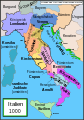
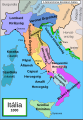
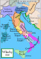
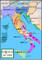
Español: Mapa de Italia hacia el año 1000. Creado por MapMaster, traducido por Molorco
English: Political map of Italy in 1000 AD (CE). Created by MapMaster, translated by Molorco
Part of a series of maps on the history of Italy:
|
| Data | 10 de abril de 2008 (fecha original de carga) |
| Fonte | No machine-readable source provided. Own work assumed (based on copyright claims). |
| Autor | No machine-readable author provided. Molorco assumed (based on copyright claims). |


Other versions
[]
SVG:
-
 català
 -
 čeština
 -
 Deutsch
 -
 English
 -
 español
 -
 français
 -
 Ido
Ido -
 italiano
 -
 magyar
 -
 polski
 -
 português
 -
 Türkçe
 -
 русский
 -
 українська
 -
 العربية
 -
 עברית
עברית -
 한국어
한국어 -
 中文
中文


PNG:
-
 polski
 -
 Türkçe
 -
 Ελληνικά
 -
 中文
中文


|
Esti ficheru SVG tien testu integráu que pue traducise fácilmente a la to llingua usando un editor de SVG como Inkscape o Adobe Illustrator. Ver más. Tamién pues descargalu y traducilu de mou manual usando un editor de testu. |
References
- Bjorklund, Oddvar; Holmboe, Haakon; Rohr, Anders (1970) Historical Atlas of the World, Barnes & Noble, NY, SBN: 389-00253-4.
- This map from Allyn & Bacon, Longman, textbook publishers.
- This map of the w:en:Holy Roman Empire
- A map from Attilios
- This map of 1050 AD Italy, from the 1923 The Historical Atlas by William R. Shepherd
- This map of 1000 AD Italy from Fordham University, adapted from Muir's Historical Atlas, (1911).
In addition, a number of other sources were consulted in an effort to determine the following matters:
- The extent of Venetian control over the cities of Dalmatia such as Zara and Spalato. Although the Venetians had been pushed off the mainland earlier, in the period around the year 1000, the Venetians made an effort to recover these cities.
- The extent of Saracen control over Corsica and Sardinia. Information is sparse. The apparent situation is that the Muslims had several bases on the coasts of these islands, but did not control the countryside (such as they did in Sicily).
- Whether or not the principalities of Capua and Benevento were separate states in the year 1000. Based on lists of their rulers (various Pandulfs and Landulfs), the answer seems to be "yes".
- Who controlled the Balkans on the southeastern border of the Kingdom of Croatia. Candidates include Bulgaria, the Byzantine Empire, Croatia, and Serbia.
As noted, there is significant disagreement among sources on these questions.
This map was commissioned by Attilios, and there is also a discussion to be found on MapMaster's English talk page.
Llicencia

|
Autorízase la copia, distribución y/o cambéu d'esti documentu baxo los términos de la Llicencia de documentación llibre GNU, versión 1.2 o cualesquier otra que nel futuru espublice la Free Software Foundation; ensin seiciones invariables, testos de portada, nin testos de contraportada. S'inclúi una copia de la llicencia na seición titulada GNU Free Documentation License. |
| Esti ficheru ta disponible baxo la llicencia Creative Commons Reconocimientu-Compartir igual 3.0 xenérica. | ||
| ||
| Esta etiqueta de llicencia s'amestó a esti ficheru como parte del anovamientu de la llicencia GFDL. |
Historial del ficheru
Calca nuna fecha/hora pa ver el ficheru como taba daquella.
| Data/Hora | Miniatura | Dimensiones | Usuariu | Comentariu | |
|---|---|---|---|---|---|
| actual | 19:56 5 ago 2021 | | 565 × 811 (710 kB) | Rowanwindwhistler | Cleanup and fake text added |
| 09:37 7 ago 2015 |  | 565 × 811 (414 kB) | Rowanwindwhistler | Ducado de Amalfi | |
| 09:33 7 ago 2015 |  | 565 × 811 (414 kB) | Rowanwindwhistler | Easier to read font used, sea colour and coast colour from https://en.wikipedia.org/wiki/Wikipedia:WikiProject_Maps/Conventions | |
| 13:00 18 och 2008 |  | 565 × 811 (1,78 MB) | Durero | Borgoña nunca fue un reino | |
| 15:42 27 abr 2008 |  | 565 × 811 (1,82 MB) | Molorco | {{Information |Description= |Source= |Date= |Author= |Permission= |other_versions= }} | |
| 15:12 11 abr 2008 |  | 565 × 811 (1,74 MB) | Molorco | {{Information |Description= |Source= |Date= |Author= |Permission= |other_versions= }} | |
| 16:19 10 abr 2008 |  | 565 × 811 (332 kB) | Molorco | {{Information |Description=Italia año 1000 }} |
Usu del ficheru
Les páxines siguientes usen esti ficheru:
Usu global del ficheru
Estes otres wikis usen esti ficheru:
- Usu en ar.wikipedia.org
- Usu en bg.wikipedia.org
- Usu en ca.wikipedia.org
- Usu en es.wikipedia.org
- Historia de Italia
- Roger I de Sicilia
- Principado de Capua
- Guaimario IV de Salerno
- Domenico Selvo
- República amalfitana
- Marca de Verona
- Ducado de Benevento
- Conquista normanda de Italia Meridional
- Principado de Salerno
- Ducado de Spoleto
- Marca de Toscana
- Anexo:Antiguos Estados de Italia
- Reino de Italia (Sacro Imperio Romano Germánico)
- Ducado de Amalfi
- Anexo:Príncipes de Capua
- Emirato de Sicilia
- Reino lombardo
- Batalla de Stilo
- Historia territorial de Italia
- Casa de Cotoner
- Kalbíes
- Historia del islam en el sur de Italia
- Familia Cesina
- Usu en gl.wikipedia.org
- Usu en io.wikipedia.org
- Usu en www.wikidata.org
- Usu en zh.wikipedia.org