Ficheru:Karte Haus Burgund 4 EN.png
Tamañu d'esta previsualización: 426 × 600 pixels. Otres resoluciones: 170 × 240 pixels | 341 × 480 pixels | 545 × 768 pixels | 727 × 1024 pixels | 2500 × 3521 pixels.
Ficheru orixinal (2500 × 3521 píxels, tamañu de ficheru: 1,33 MB, triba MIME: image/png)
| Descripción |
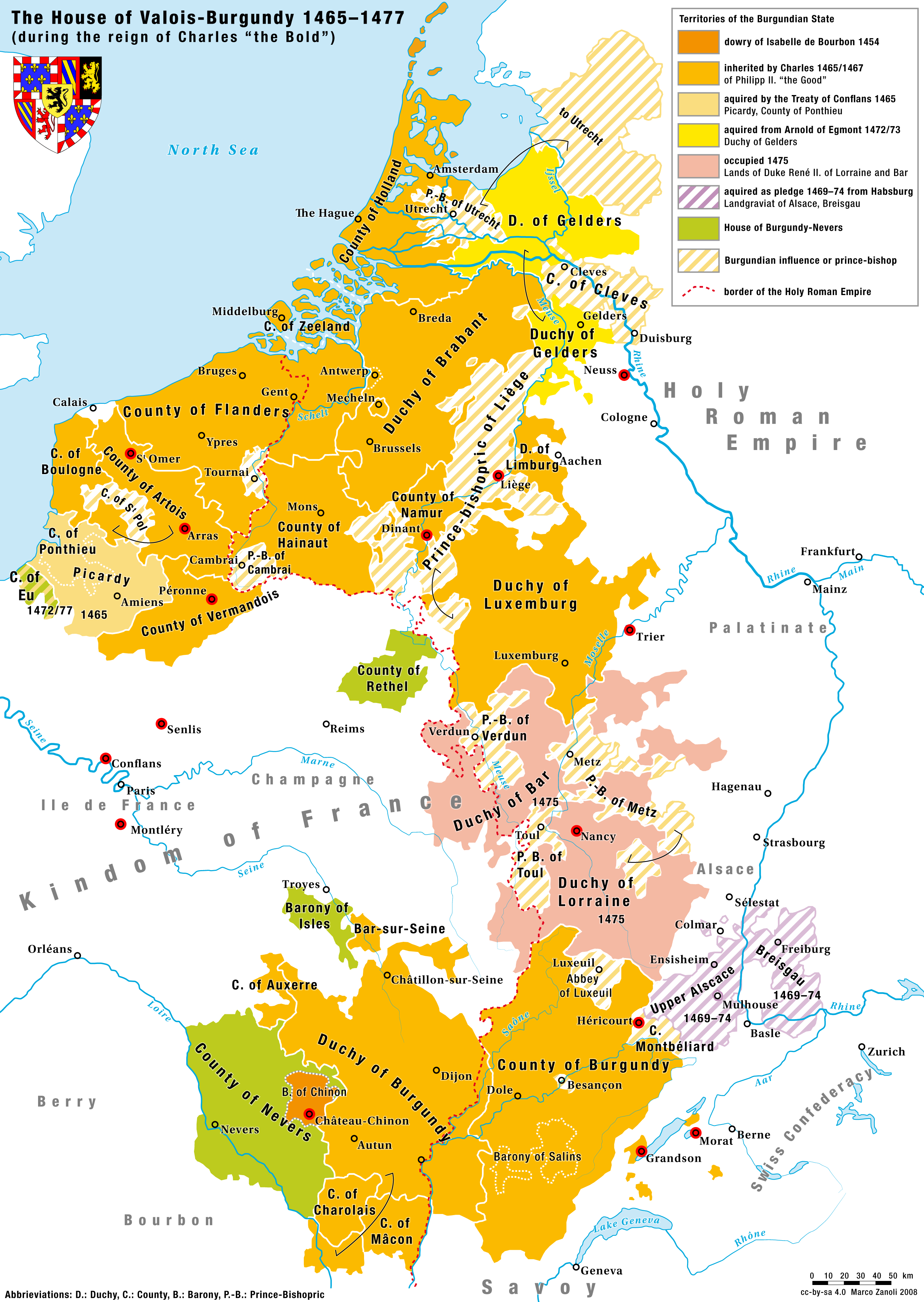
English: Territories of the House of Valois-Burgundy during the reign of Charles the Bold, 1465/67–1477 |
|
| Data | 2.5.2008 | |
| Fonte | Trabayu propiu | |
| Autor | Marco Zanoli (sidonius 12:09, 2 May 2008 (UTC)) | |
| Permisu (Cómo reutilizar esti ficheru) |
|
|
| Otres versiones |
Coat of arms from: 
|


-ka.svg)

Historial del ficheru
Calca nuna fecha/hora pa ver el ficheru como taba daquella.
| Data/Hora | Miniatura | Dimensiones | Usuariu | Comentariu | |
|---|---|---|---|---|---|
| actual | 16:10 24 ago 2023 | | 2500 × 3521 (1,33 MB) | Sidonius | corrected some mistakes and adapted to layout and design of German and French Version |
| 04:52 4 xnt 2010 |  | 1200 × 1690 (652 kB) | DcoetzeeBot | Remove watermark, add author and license data to image metadata, decrease filesize with pngcrush | |
| 14:04 17 xun 2008 |  | 1200 × 1690 (798 kB) | Sidonius | small corrections, important cities and battles marked with red dot, county of cleves added etc. | |
| 12:09 2 may 2008 |  | 1200 × 1787 (529 kB) | Sidonius | {{Information |Description={{en|Territories of the House of Valois-Burgundy during the reign of Charles the Bold, 1465/67–1477}} |Source=own work |Date=2.5.2008 |Author=Marco Zanoli (~~~~) |Permission={{Attribution sidonius}} |other_versions=Coat of arm |
Usu del ficheru
Les páxines siguientes usen esti ficheru:
Usu global del ficheru
Estes otres wikis usen esti ficheru:
- Usu en ar.wikipedia.org
- Usu en azb.wikipedia.org
- Usu en az.wikipedia.org
- Usu en be.wikipedia.org
- Usu en bg.wikipedia.org
- Usu en ca.wikipedia.org
- Usu en cs.wikipedia.org
- Usu en de.wikipedia.org
- Usu en el.wikipedia.org
- Usu en en.wikipedia.org
- Usu en eo.wikipedia.org
- Usu en es.wikipedia.org
- Usu en et.wikipedia.org
- Usu en eu.wikipedia.org
- Usu en fa.wikipedia.org
- Usu en fi.wikipedia.org
- Usu en fr.wikipedia.org
- Usu en ga.wikipedia.org
- Usu en gl.wikipedia.org
- Usu en he.wikipedia.org
- Usu en hr.wikipedia.org
- Usu en hu.wikipedia.org
- Usu en hy.wikipedia.org
Ver más usos globales d'esti ficheru.