Ficheru:Kayseri districts.png

Tamañu d'esta previsualización: 729 × 600 pixels. Otres resoluciones: 292 × 240 pixels | 583 × 480 pixels | 999 × 822 pixels.
Ficheru orixinal (999 × 822 píxels, tamañu de ficheru: 51 kB, triba MIME: image/png)
Resume
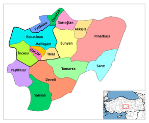
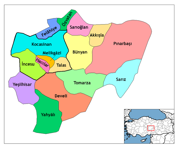
| Descripción | Map of the districts of Kayseri province in Turkey. Created by Rarelibra 21:59, 1 December 2006 (UTC) for public domain use, using MapInfo Professional v8.5 and various mapping resources. Edited by One Homo Sapiens Corrected text where İ, Ş, ı, ğ, or ş occurs in name. Source: [statoids-com]. Increased font size and enhanced color differences among adjacent districts. User:Sae1962 Marked the boundaries of the provincial centre, the city of Kayseri, with bold lines. |
| Data | 1 de avientu de 2006 (fecha original de carga) |
| Fonte | No machine-readable source provided. Own work assumed (based on copyright claims). |
| Autor | No machine-readable author provided. Rarelibra assumed (based on copyright claims). |
Llicencia
| Yo, el titular de los drechos d'autor d'esta obra, la llibero como dominiu públicu. Esto s'aplica nel mundu ensembre. En dellos países seique esto nun seya posible llegalmente; nesti casu: Doi a cualesquier persona permisu pa usar esta obra pa cualesquier propósitu, ensin denguna condición, menos si eses condiciones requierense pola llei. |
Historial del ficheru
Calca nuna fecha/hora pa ver el ficheru como taba daquella.
| Data/Hora | Miniatura | Dimensiones | Usuariu | Comentariu | |
|---|---|---|---|---|---|
| actual | 11:25 30 xnt 2009 | | 999 × 822 (51 kB) | Sae1962 | {{Information |Description=Map of the districts of Kayseri province in Turkey. Created by Rarelibra 21:59, 1 December 2006 (UTC) for public domain use, using MapInfo Professional v8.5 and various mapping resources. Edited by [[User:One |
| 08:24 4 may 2009 |  | 999 × 822 (50 kB) | Sae1962 | Added long vowels for better reading. | |
| 23:54 28 avi 2008 |  | 1056 × 816 (35 kB) | One Homo Sapiens | Corrected text where İ,Ş,ı,ğ,or ş occurs in name. Source: [statoids-com]. Increased font size and enhanced color differences among adjacent districts. | |
| 21:59 1 avi 2006 |  | 1056 × 816 (33 kB) | Rarelibra | Map of the districts of Kayseri province in Turkey. Created by ~~~~ for public domain use, using MapInfo Professional v8.5 and various mapping resources. |
Usu del ficheru
La páxina siguiente usa esti ficheru:
Usu global del ficheru
Estes otres wikis usen esti ficheru:
- Usu en az.wikipedia.org
- Usu en be.wikipedia.org
- Usu en ca.wikipedia.org
- Usu en cs.wikipedia.org
- Usu en de.wikipedia.org
- Kayseri
- Talas (Kayseri)
- Yahyalı
- Hacılar (Kayseri)
- Talas (Bezirk)
- Tomarza
- Wikipedia:Kartenwerkstatt/Archiv/2011-01
- Wikipedia:Kartenwerkstatt/Archiv/2011-05
- Develi (Kayseri)
- Vorlage:Navigationsleiste Landkreise der Provinz Kayseri
- Akkışla
- Bünyan
- Felahiye
- İncesu (Kayseri)
- Kocasinan
- Melikgazi
- Özvatan
- Pınarbaşı (Kayseri)
- Sarıoğlan
- Sarız
- Yeşilhisar (Kayseri)
- Usu en diq.wikipedia.org
- Usu en en.wikipedia.org
Ver más usos globales d'esti ficheru.