Ficheru:Kingdom of Arles 1000.svg

Tamañu de la vista previa PNG d'esti ficheru SVG: 485 × 340 pixels. Otres resoluciones: 320 × 224 pixels | 640 × 449 pixels | 1024 × 718 pixels | 1280 × 897 pixels | 2560 × 1795 pixels.
Ficheru orixinal (ficheru SVG, 485 × 340 píxels nominales, tamañu de ficheru: 1,25 MB)
Resume
Este gráfico vectorial fue creado con Inkscape .


.svg)
.svg)
.svg)
.svg)
.svg)


.svg)
.svg)
.svg)


.png)
.png)


.svg)


.svg)

.svg)


.svg)
.svg)
.svg)
.svg)


.svg)
.png)


.svg)


.svg)
.svg)


.svg)


.svg)


.svg)
.svg)
.svg)
.svg)
.svg)
.svg)
.svg)
.svg)
_cropped.svg)
.svg)
.svg)
.svg)
.svg)
.svg)
.svg)
.svg)
.svg)
.svg)
.svg)
.svg)
.svg)
.svg)
.svg)
.svg)
.svg)
.svg)
.svg)
.svg)
.svg)
.svg)
.svg)
.svg)
.svg)
.svg)
.svg)
.svg)
.svg)
.svg)
.svg)
.svg)
.svg)
.svg)
.svg)
.svg)
.svg)
.svg)
.svg)
.svg)
.svg)
.svg)
.svg)
.svg)
.svg)
.svg)
Llicencia
Este archivo está disponible bajo la licencia Creative Commons Attribution-Share Alike 4.0 International.
- Ye llibre:
- pa compartir – pa copiar, distribuir y comunicar públicamente la obra
- pa remezclar – p'adautar la obra
- Baxo les condiciones siguientes:
- reconocimientu – Tienes de dar el créitu apropiáu, apurrir un enllaz a la llicencia ya indicar si realizasti dalgún cambéu. Puedes faelo de cualquier mou razonable ,pero non de manera que suxera l'encontu del autor pa ti o pal usu que faigas.
- compartir igual – Si entemeces, tresformes o te bases nesti material, tienes de distribuir les tos contribuciones baxo la mesma llicencia o una compatible cola orixinal.
Historial del ficheru
Calca nuna fecha/hora pa ver el ficheru como taba daquella.
| Data/Hora | Miniatura | Dimensiones | Usuariu | Comentariu | |
|---|---|---|---|---|---|
| actual | 14:41 23 may 2016 | | 485 × 340 (1,25 MB) | Alphathon | Corrected status of Bohemia |
| 18:16 22 may 2016 |  | 485 × 340 (1,24 MB) | Alphathon | Split Capua from Benevento and removed both from HRE, along with Spoleto | |
| 16:42 22 may 2016 |  | 485 × 340 (1,23 MB) | Alphathon | Added Welsh kingdoms/principalities and removed Rügen from the HRE | |
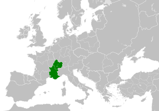
| 15:39 22 may 2016 |  | 485 × 340 (1,23 MB) | Alphathon | == {{int:filedesc}} == {{Inkscape}} {{Information |Description={{en|A map of the Kingdom of Arles/Arelat/Burgundy within Europe circa 1000 CE. The main subdivisions of the Byzantine Empire, Holy Roman Empire, Burgundy, France a... |
Usu del ficheru
La páxina siguiente usa esti ficheru:
Usu global del ficheru
Estes otres wikis usen esti ficheru:
- Usu en az.wikipedia.org
- Usu en ca.wikipedia.org
- Usu en cs.wikipedia.org
- Usu en el.wikipedia.org
- Usu en en.wikipedia.org
- Usu en eo.wikipedia.org
- Usu en es.wikipedia.org
- Usu en fa.wikipedia.org
- Usu en fi.wikipedia.org
- Usu en fr.wikipedia.org
- Usu en he.wikipedia.org
- Usu en hu.wikipedia.org
- Usu en id.wikipedia.org
- Usu en it.wikipedia.org
- Usu en it.wikiquote.org
- Usu en ko.wikipedia.org
- Usu en lv.wikipedia.org
- Usu en mt.wikipedia.org
- Usu en pl.wikipedia.org
- Usu en ro.wikipedia.org
- Usu en sl.wikipedia.org
- Usu en th.wikipedia.org
- Usu en uk.wikipedia.org
- Usu en vi.wikipedia.org
- Usu en www.wikidata.org
- Usu en zh.wikipedia.org
.svg)