Ficheru:LanguageMap-Kikongo-Kituba.png

Tamañu d'esta previsualización: 800 × 529 pixels. Otres resoluciones: 320 × 212 pixels | 640 × 423 pixels | 1024 × 677 pixels | 1420 × 939 pixels.
Ficheru orixinal (1420 × 939 píxels, tamañu de ficheru: 89 kB, triba MIME: image/png)
Resume
| Descripción |
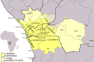
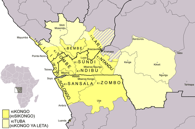
Dialect map of Kikongo. Dark yellow areas are inhabited mainly by first language speakers of the various dialects/languages of Kikongo. Names of some dialects/languages are written on the map. Pale yellow areas are inhabited by first and second language speakers of Kituba (a.k.a. Kikongo ya Leta), which is the lingua franca in the area. Kituba is understood by most speakers of Kikongo. Map drawn by Risto Kupsala. Details are based on the language maps of Ethnologue and several other sources. |
| Data | 2 de abril de 2006 (fecha original de carga) |
| Fonte | No machine-readable source provided. Own work assumed (based on copyright claims). |
| Autor | No machine-readable author provided. Rasulo~commonswiki assumed (based on copyright claims). |
Llicencia
| Yo, el titular de los drechos d'autor d'esta obra, la llibero como dominiu públicu. Esto s'aplica nel mundu ensembre. En dellos países seique esto nun seya posible llegalmente; nesti casu: Doi a cualesquier persona permisu pa usar esta obra pa cualesquier propósitu, ensin denguna condición, menos si eses condiciones requierense pola llei. |
Historial del ficheru
Calca nuna fecha/hora pa ver el ficheru como taba daquella.
| Data/Hora | Miniatura | Dimensiones | Usuariu | Comentariu | |
|---|---|---|---|---|---|
| actual | 00:37 25 feb 2021 | | 1420 × 939 (89 kB) | Somebody040404 | Reverted to version as of 10:10, 29 March 2018 (UTC) |
| 00:26 25 feb 2021 |  | 1420 × 939 (82 kB) | Somebody040404 | ||
| 10:10 29 mar 2018 |  | 1420 × 939 (89 kB) | Maphobbyist | South Sudan border | |
| 21:24 20 avi 2007 |  | 1420 × 939 (60 kB) | Rasulo~commonswiki | Dialect map of Kikongo. Dark yellow areas are inhabited mainly by native speakers of the various dialects/languages of Ki(si)kongo. Names of some dialects/languages are written on the map. Pale yellow areas are inhabited by first and second language speak | |
| 12:12 22 xnt 2006 |  | 718 × 518 (26 kB) | Rasulo~commonswiki | ||
| 09:49 2 abr 2006 |  | 571 × 471 (20 kB) | Rasulo~commonswiki | Dialect map of Kikongo Dark green areas are inhabited mainly by first language speakers of the various dialects/languages of Kikongo. Names of some dialects/languages are written on the map. Light green areas are inhabited by first and second language spe |
Usu del ficheru
Les páxines siguientes usen esti ficheru:
Usu global del ficheru
Estes otres wikis usen esti ficheru:
- Usu en af.wikipedia.org
- Usu en ar.wikipedia.org
- Usu en az.wiktionary.org
- Usu en bn.wikipedia.org
- Usu en ca.wikipedia.org
- Usu en cs.wikipedia.org
- Usu en da.wikipedia.org
- Usu en de.wikipedia.org
- Usu en en.wikipedia.org
- Usu en eo.wikipedia.org
- Usu en es.wikipedia.org
- Usu en eu.wikipedia.org
- Usu en fi.wikipedia.org
- Usu en frr.wikipedia.org
- Usu en fr.wikipedia.org
- Usu en fr.wiktionary.org
- Usu en gl.wikipedia.org
Ver más usos globales d'esti ficheru.