Ficheru:Locator Electoral Palatinate within the Holy Roman Empire (1618).svg

Tamañu de la vista previa PNG d'esti ficheru SVG: 658 × 600 pixels. Otres resoluciones: 263 × 240 pixels | 527 × 480 pixels | 843 × 768 pixels | 1123 × 1024 pixels | 2247 × 2048 pixels | 2769 × 2524 pixels.
Ficheru orixinal (ficheru SVG, 2769 × 2524 píxels nominales, tamañu de ficheru: 1 MB)
.svg)
Resume
| Descripción |
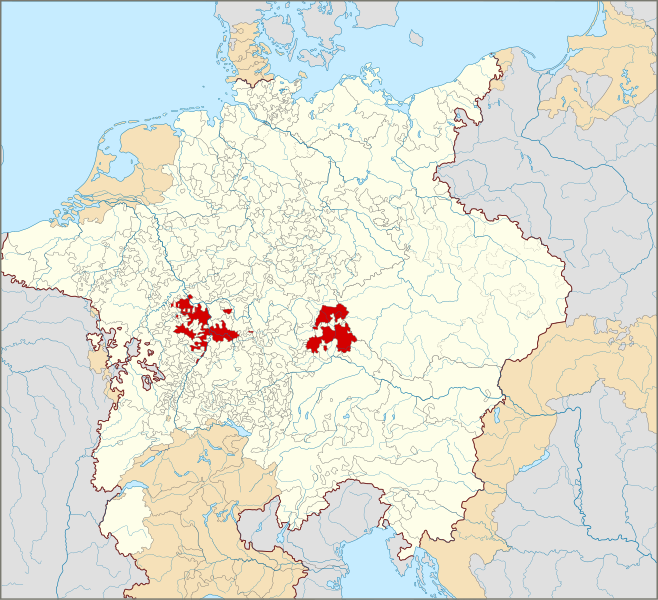
English: Locator Map of the Electoral Palatinate within the Holy Roman Empire (1618)
The Electoral Palatinate in 1618.
Territories of the Holy Roman Empire.
Territories connected with the Holy Roman Empire, including the Imperial Italy, the Swiss Confederacy, Barrois mouvant, Sedan, Lauenburg and Bütow, Ducal Prussia, the Duchy of Schleswig and the Dutch Republic.
Territories outside the Holy Roman Empire.
Nederlands: Locatiekaart van de Keur-Palts binnen het Heilige Roomse Rijk (1618) |
| Data | |
| Fonte |
|
| Autor |
|
Llicencia
Yo, el titular de los drechos d'autor d'esta obra, la espublizo baxo la siguiente llicencia:
Este archivo está disponible bajo la licencia Creative Commons Atribución-CompartirIgual 4.0 Internacional.
- Ye llibre:
- pa compartir – pa copiar, distribuir y comunicar públicamente la obra
- pa remezclar – p'adautar la obra
- Baxo les condiciones siguientes:
- reconocimientu – Tienes de dar el créitu apropiáu, apurrir un enllaz a la llicencia ya indicar si realizasti dalgún cambéu. Puedes faelo de cualquier mou razonable ,pero non de manera que suxera l'encontu del autor pa ti o pal usu que faigas.
- compartir igual – Si entemeces, tresformes o te bases nesti material, tienes de distribuir les tos contribuciones baxo la mesma llicencia o una compatible cola orixinal.
Historial del ficheru
Calca nuna fecha/hora pa ver el ficheru como taba daquella.
| Data/Hora | Miniatura | Dimensiones | Usuariu | Comentariu | |
|---|---|---|---|---|---|
| actual | 00:55 28 xin 2015 | | 2769 × 2524 (1 MB) | Sir Iain | Corrected Bohemian border |
| 14:24 27 xin 2015 |  | 2769 × 2524 (1018 kB) | Sir Iain | Corrected mistake in Bohemia | |
| 14:19 22 xin 2015 |  | 2769 × 2524 (1022 kB) | Sir Iain | Redone Schleswig-Holstein | |
| 00:53 5 xin 2015 |  | 2769 × 2524 (998 kB) | Sir Iain | Savoy shown as core territory of the HRR | |
| 20:27 23 avi 2014 |  | 2769 × 2524 (998 kB) | Sir Iain | Removed the Imperial border between Germany and the Netherlands | |
| 01:18 23 avi 2014 |  | 2769 × 2524 (1002 kB) | Sir Iain | User created page with UploadWizard |
Usu del ficheru
La páxina siguiente usa esti ficheru:
Usu global del ficheru
Estes otres wikis usen esti ficheru:
- Usu en af.wikipedia.org
- Usu en ar.wikipedia.org
- Usu en az.wikipedia.org
- Usu en bg.wikipedia.org
- Usu en cs.wikipedia.org
- Usu en en.wikipedia.org
- Usu en fa.wikipedia.org
- Usu en fr.wikipedia.org
- Usu en fy.wikipedia.org
- Usu en it.wikipedia.org
- Usu en ko.wikipedia.org
- Usu en nl.wikipedia.org
- Usu en ru.wikipedia.org
- Usu en simple.wikipedia.org
- Usu en sr.wikipedia.org
- Usu en uk.wikipedia.org
- Usu en www.wikidata.org
.svg)