Ficheru:Lockheed 8 Sirius 'Tingmissartoq' at the National Air and Space Museum, Washington DC.jpg

Ficheru orixinal (1600 × 1066 píxels, tamañu de ficheru: 503 kB, triba MIME: image/jpeg)
| Descripción |
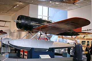
Every possible space in the aircraft was utilized, including the wings and floats, which contained the gasoline tanks. There was plenty of emergency equipment in case the Lindberghs had to make a forced landing in the frozen wilderness. From New York, the Lindberghs flew up the eastern border of Canada to Hopedale, Labrador. From Hopedale they made the first major overwater hop, 650 miles to Godthaab, Greenland, where the Sirius acquired its name—Tingmissartoq, which in Eskimo means "one who flies like a big bird." After crisscrossing Greenland to Baffin Island and back, and then on to Iceland, the Lindberghs proceeded to the major cities of Europe and as far east as Moscow, down the west coast of Africa, and across the South Atlantic to South America. where they flew down the Amazon, and then north through Trinidad and Barbados and back to the United States. They returned to New York on December 19, having traveled 30,000 miles to four continents and twenty-one countries. The information gained from the trip proved invaluable in planning commercial air transport routes for the North and South Atlantic. The aircraft was in the American Museum of Natural History in New York City until 1955. The AirForce Museum in Dayton, Ohio, then acquired it and transferred it to the Smithsonian in 1959. collections.nasm.si.edu/code/emuseum.asp?profile=objects&... |
| Data | |
| Fonte | Lockheed 8 Sirius "Tingmissartoq" |
| Autor | Cliff from I now live in Arlington, VA (Outside Washington DC), USA |
| Posición de la cámara | | Ubicación de esta y otras imágenes en: OpenStreetMap |
|---|
Llicencia
- Ye llibre:
- pa compartir – pa copiar, distribuir y comunicar públicamente la obra
- pa remezclar – p'adautar la obra
- Baxo les condiciones siguientes:
- reconocimientu – Tienes de dar el créitu apropiáu, apurrir un enllaz a la llicencia ya indicar si realizasti dalgún cambéu. Puedes faelo de cualquier mou razonable ,pero non de manera que suxera l'encontu del autor pa ti o pal usu que faigas.
| Esta imagen fue publicada en Flickr por cliff1066™ en https://www.flickr.com/photos/28567825@N03/3344241041. La imagen fue revisada el 15 de payares de 2009 por el robot FlickreviewR y confirmó tener licencia bajo los términos de cc-by-2.0. |
Historial del ficheru
Calca nuna fecha/hora pa ver el ficheru como taba daquella.
| Data/Hora | Miniatura | Dimensiones | Usuariu | Comentariu | |
|---|---|---|---|---|---|
| actual | 18:01 15 pay 2009 | | 1600 × 1066 (503 kB) | Geo Swan | {{Information |Description=Every possible space in the aircraft was utilized, including the wings and floats, which contained the gasoline tanks. There was plenty of emergency equipment in case the Lindberghs had to make a forced landing in the frozen wil |
Usu del ficheru
La páxina siguiente usa esti ficheru:
Usu global del ficheru
Estes otres wikis usen esti ficheru:
- Usu en ar.wikipedia.org
- Usu en ca.wikipedia.org
- Usu en en.wikipedia.org
- Usu en es.wikipedia.org
- Usu en fa.wikipedia.org
- Usu en fr.wikipedia.org
- Usu en gl.wikipedia.org
- Usu en id.wikipedia.org
- Usu en ja.wikipedia.org
- Usu en no.wikipedia.org
- Usu en pt.wikipedia.org
- Usu en vi.wikipedia.org
- Usu en www.wikidata.org