Ficheru orixinal(ficheru SVG, 3492 × 2966 píxels nominales, tamañu de ficheru: 726 kB)

Esti ficheru ye de Wikimedia Commons y puen usalu otros proyeutos. La descripción de la páxina de descripción del ficheru s'amuesa darréu.

Resume

Descripción
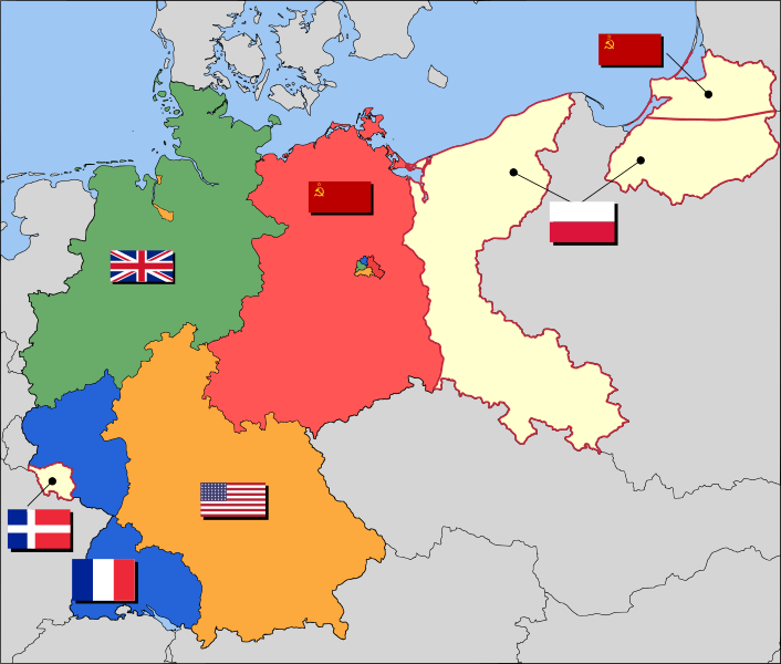
العربية: حدود المناطق المحتلة في ألمانيا عام 1957. الاراضي شرق خط نيس تحت السيطرة البولندية والسوفييتية، تظهر بلون ابيض. برلين منطقة مسيطر عليها من عدة بلدان داخل المنطقة السوفييتة.
English: Occupation zone borders in Germany, 1947. The territories east of the Oder-Neisse line, under Polish and Soviet administration/annexation, are shown as cream as is the likewise detached Saar protectorate. Berlin is the multinational area within the Soviet zone.
Français : Carte des zones d'occupation de l'Allemagne : le protectorat français de la Sarre apparait en blanc-crème, comme la Silésie, la Poméranie et les autres régions allemandes orientales annexées par la Pologne et l'Union Soviétique.
Deutsch: Grenzen der Besatzungszonen in Deutschland, 1947. Die Gebiete östlich der Oder-Neiße-Grenze, unter polnischer und sowjetischer Verwaltung/Annexion, sowie das Saar-Protektorat sind cremefarben dargestellt. Berlin ist ein multinationales Gebiet inmitten der sowjetischen Besatzungszone.
Data 17 de marzu de 2008 (fecha original de carga)
Fonte Based on map data of the IEG-Maps project (Andreas Kunz, B. Johnen and Joachim Robert Moeschl: University of Mainz) - www.ieg-maps.uni-mainz.de.
Autor User:52 Pickup
SVG desarrollo
InfoField
 
El código fuente de esta imagen SVG es inválido por 11 errores.
 
Este mapa, inválido según el W3C, fue creado con Inkscape.

Llicencia

w:es:Creative Commons
reconocimientu compartir igual
Este archivo se encuentra bajo la licencia Creative Commons Genérica de Atribución/Compartir-Igual 2.5.
Ye llibre:
  • pa compartir – pa copiar, distribuir y comunicar públicamente la obra
  • pa remezclar – p'adautar la obra
Baxo les condiciones siguientes:
  • reconocimientu – Tienes de dar el créitu apropiáu, apurrir un enllaz a la llicencia ya indicar si realizasti dalgún cambéu. Puedes faelo de cualquier mou razonable ,pero non de manera que suxera l'encontu del autor pa ti o pal usu que faigas.
  • compartir igual – Si entemeces, tresformes o te bases nesti material, tienes de distribuir les tos contribuciones baxo la mesma llicencia o una compatible cola orixinal.

Rexistru de xubíes orixinal

Transferido desde en.wikipedia a Commons por Broadbeer usando CommonsHelper.

Aquí se muestra la página de descripción original. Los siguientes nombres de usuario se refieren a en.wikipedia.
  • 2008-03-17 19:50 52 Pickup 3492×2966× (760290 bytes) Changes to fill and border colours. Made differences clearer between occupation zones and eventual territorial losses.
  • 2007-08-31 14:57 52 Pickup 3492×2966× (755561 bytes) New version: regions placed under Polish and Soviet administration now presented slightly differently (borders instead of colour fill), Saar colour now only slightly different to French zone (still needs some work)
  • 2007-08-10 09:50 52 Pickup 3492×2966× (751829 bytes) oops, now with fixed image size
  • 2007-08-10 09:47 52 Pickup 744×1052× (751774 bytes) {{Information| |Description= Germany in the aftermath of World War II: 1 September 1945 |Source= Based on map data of the IEG-Maps project (Andreas Kunz, B. Johnen and Joachim Robert Moeschl: University of Mainz) - [http://www.ieg-maps.uni-mainz.de www.ie
Annotations
InfoField
This image is annotated: View the annotations at Commons

Pies

Añade una explicación corta acerca de lo que representa este archivo
Occupation map of Germany after WW2

Elementos representados en este archivo

representa a

causado por español

Historial del ficheru

Calca nuna fecha/hora pa ver el ficheru como taba daquella.

Data/HoraMiniaturaDimensionesUsuariuComentariu
actual04:37 1 avi 2017Miniatura de la versión a fecha de 04:37 1 avi 20173492 × 2966 (726 kB)SammimackUpdated flags and colours
14:13 3 xnt 2015Miniatura de la versión a fecha de 14:13 3 xnt 20153492 × 2966 (728 kB)LichaoshengNew 48-Star US Flag from File:US flag 48 stars.svg
14:00 3 xnt 2015Miniatura de la versión a fecha de 14:00 3 xnt 20153492 × 2966 (742 kB)LichaoshengReverted to version as of 18:46, 8 October 2008
15:19 4 feb 2012Miniatura de la versión a fecha de 15:19 4 feb 20123492 × 2966 (742 kB)AnonMoosReverted to version as of 18:46, 8 October 2008 -- Kaliningrad had quite different status and fate from that of East Germany proper...
19:44 20 xin 2012Miniatura de la versión a fecha de 19:44 20 xin 20123492 × 2966 (742 kB)Sammy pomponKaliningrado is occuped by USSR.
18:46 8 och 2008Miniatura de la versión a fecha de 18:46 8 och 20083492 × 2966 (742 kB)File Upload Bot (Magnus Manske) {{BotMoveToCommons|en.wikipedia}} {{Information |Description={{en|Occupation zone borders in Germany, 1947. The territories east of the en:Oder-Neisse line, under Polish and Soviet administration/annexation, are shown as white as is the likewise det

Les páxines siguientes usen esti ficheru:

Usu global del ficheru

Estes otres wikis usen esti ficheru:

Ver más usos globales d'esti ficheru.

Metadatos