Ficheru:North German Confederation 1870.svg

Tamañu de la vista previa PNG d'esti ficheru SVG: 450 × 456 pixels. Otres resoluciones: 237 × 240 pixels | 474 × 480 pixels | 758 × 768 pixels | 1011 × 1024 pixels | 2021 × 2048 pixels.
Ficheru orixinal (ficheru SVG, 450 × 456 píxels nominales, tamañu de ficheru: 705 kB)
Resume


.svg)
.svg)
.svg)
.svg)
.svg)


.svg)
.svg)
.svg)


.png)
.png)


.svg)


.svg)

.svg)


.svg)
.svg)
.svg)
.svg)


.svg)
.png)


.svg)


.svg)
.svg)


.svg)


.svg)


.svg)
.svg)
.svg)
.svg)
.svg)
.svg)
.svg)
_cropped.svg)
.svg)
.svg)
.svg)
.svg)
.svg)
.svg)
.svg)
.svg)
.svg)
.svg)
.svg)
.svg)
.svg)
.svg)
.svg)
.svg)
.svg)
.svg)
.svg)
.svg)
.svg)
.svg)
.svg)
.svg)
.svg)
.svg)
.svg)
.svg)
.svg)
.svg)
.svg)
.svg)
.svg)
.svg)
.svg)
.svg)
.svg)
.svg)
.svg)
.svg)
.svg)
.svg)
.svg)
.svg)
.svg)
Llicencia
Este archivo está disponible bajo la licencia Creative Commons Attribution-Share Alike 4.0 International.
- Ye llibre:
- pa compartir – pa copiar, distribuir y comunicar públicamente la obra
- pa remezclar – p'adautar la obra
- Baxo les condiciones siguientes:
- reconocimientu – Tienes de dar el créitu apropiáu, apurrir un enllaz a la llicencia ya indicar si realizasti dalgún cambéu. Puedes faelo de cualquier mou razonable ,pero non de manera que suxera l'encontu del autor pa ti o pal usu que faigas.
- compartir igual – Si entemeces, tresformes o te bases nesti material, tienes de distribuir les tos contribuciones baxo la mesma llicencia o una compatible cola orixinal.
Historial del ficheru
Calca nuna fecha/hora pa ver el ficheru como taba daquella.
| Data/Hora | Miniatura | Dimensiones | Usuariu | Comentariu | |
|---|---|---|---|---|---|
| actual | 02:58 1 xun 2016 | | 450 × 456 (705 kB) | Alphathon | Various corrections to the states of the North German Confederation |
| 05:22 31 may 2016 |  | 450 × 456 (662 kB) | Alphathon | Uploaded wrong file | |
| 05:22 31 may 2016 |  | 450 × 456 (725 kB) | Alphathon | Minor corrections (Tarasp and post-1818 German Confederation border change) | |
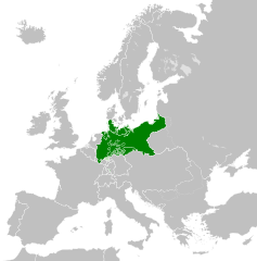
| 02:40 31 may 2016 |  | 450 × 456 (662 kB) | Alphathon | == {{int:filedesc}} == {{Inkscape}} {{Information |Description={{en|A map of the en:North German Confederation within Europe circa 1870 CE.}} |Source= {{Derived from|Blank_map_of_Europe.svg|display=50}} |Date=2016-05-31 |Author=*[[:File:Bla... |
Usu del ficheru
Nun hai páxines qu'usen esti ficheru.
Usu global del ficheru
Estes otres wikis usen esti ficheru:
- Usu en ang.wikipedia.org
- Usu en ar.wikipedia.org
- Usu en azb.wikipedia.org
- Usu en bg.wikipedia.org
- Usu en cs.wikipedia.org
- Usu en en.wikipedia.org
- Usu en es.wikipedia.org
- Usu en eu.wikipedia.org
- Usu en fa.wikipedia.org
- Usu en fi.wikipedia.org
- Usu en fr.wikipedia.org
- Usu en he.wikipedia.org
- Usu en hr.wikipedia.org
- Usu en is.wikipedia.org
- Usu en it.wikipedia.org
- Usu en ko.wikipedia.org
- Usu en lt.wikipedia.org
- Usu en lv.wikipedia.org
- Usu en ms.wikipedia.org
- Usu en pl.wikipedia.org
- Usu en pt.wikipedia.org
- Usu en ru.wikipedia.org
- Usu en sv.wikipedia.org
- Usu en th.wikipedia.org
- Usu en tr.wikipedia.org
- Usu en vi.wikipedia.org
- Usu en zh.wikipedia.org