Ficheru:North Sea location map.svg

Ficheru orixinal (ficheru SVG, 988 × 1159 píxels nominales, tamañu de ficheru: 582 kB)
Resume
| Descripción |
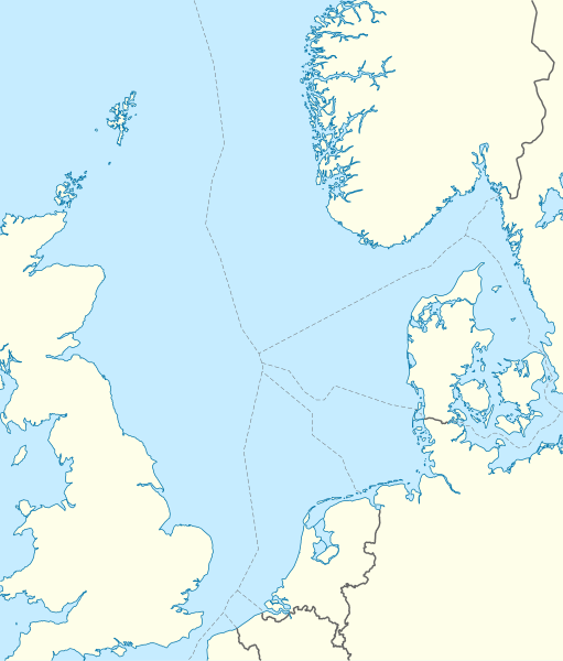
Deutsch: Positionskarte der Nordsee
Quadratische Plattkarte, N-S-Streckung 180 %. Geographische Begrenzung der Karte:
English: Location map of the North Sea
Equirectangular projection, N/S stretching 180 %. Geographic limits of the map:
|
|
| Data | ||
| Fonte | own work, using World Data Base II data | |
| Autor | NordNordWest | |
| Permisu (Cómo reutilizar esti ficheru) |
Este archivo se encuentra bajo la licencia Creative Commons Reconocimiento-Compartir bajo la misma licencia 3.0 Alemania.
 Este archivo se encuentra bajo la licencia Creative Commons Reconocimiento-Compartir bajo la misma licencia 3.0 Alemania.
|
|
| Otres versiones |
Obras derivadas de ésta:
|


|
Este mapa se ha hecho o mejorado en el Kartenwerkstatt (taller cartográfico) alemán. También puede proponer mapas para mejorar.
|
Historial del ficheru
Calca nuna fecha/hora pa ver el ficheru como taba daquella.
| Data/Hora | Miniatura | Dimensiones | Usuariu | Comentariu | |
|---|---|---|---|---|---|
| actual | 08:49 18 xun 2010 | | 988 × 1159 (582 kB) | NordNordWest | == {{int:filedesc}} == {{Information |Description= {{de|Positionskarte der Nordsee}} Quadratische Plattkarte, N-S-Streckung 180 %. Geographische Begrenzung der Karte: * N: 62.5° N * S: 50.5° N * W: 5.2° W * O: 13.2° O {{en|Location map |
Usu del ficheru
Les páxines siguientes usen esti ficheru:
Usu global del ficheru
Estes otres wikis usen esti ficheru:
- Usu en ar.wikipedia.org
- Usu en az.wikipedia.org
- Usu en ban.wikipedia.org
- Usu en be.wikipedia.org
- Usu en ca.wikipedia.org
- Usu en ceb.wikipedia.org
- Usu en cs.wikipedia.org
- Usu en da.wikipedia.org
- Usu en de.wikipedia.org
- Piper Alpha
- Troll A
- HGÜ Troll
- Ekofisk
- Offshore-Windpark Butendiek
- Wikipedia:Kartenwerkstatt/Positionskarten/Andere
- Offshore-Windpark Rhyl Flats
- Offshore-Windpark North Hoyle
- Offshore-Windpark Borkum Riffgrund
- Offshore-Windpark Sandbank
- Offshore-Windpark DanTysk
- Offshore-Windpark Nördlicher Grund
- Offshore-Windpark Global Tech I
- BARD Offshore 1
- Trianel Windpark Borkum
- Offshore-Windpark Hohe See
- Offshore-Windpark He dreiht
- Offshore-Windpark Veja Mate
- BorWin1
- Offshore-Windpark London Array
- Offshore-Windpark Gwynt y Môr
- Vorlage:Positionskarte Nordsee
- Offshore-Windpark Riffgat
- Gannet Alpha
- Offshore-Windpark Albatros
- Offshore-Windpark Greater Gabbard
- Elgin Wellhead Platform
- Alvheim
- Wikipedia:Auskunft/Archiv/2013/Woche 27
- Offshore-Windpark Merkur
- Offshore-Windpark Nordergründe
Ver más usos globales d'esti ficheru.