Ficheru:Philippines.A2002088.0220.1km.jpg

Ficheru orixinal (1150 × 1500 píxels, tamañu de ficheru: 417 kB, triba MIME: image/jpeg)
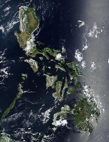
Credit: Jacques Descloitres, MODIS Land Rapid Response Team, NASA/GSFC
Red dots (or outlines in the high-resolution imagery) indicate MODIS9 detection of thermal anomalies throughout the Philippines on March 29, 2002. In most cases, the anomaly is a fire, for example, all the locations marked on the northernmost island, Luzon. However, south of center, on the southern tip of Negros, the thermal anomaly is likely volcanic activity, and the red dot left of center of the main part of Mindanao (lower right) marks the location of a volcano called Mount Ragang.
http://visibleearth.nasa.gov/view_rec.php?id=2656
| Este archivo es de dominio público porque fue creado por la NASA. Las políticas sobre copyright de la NASA estipulan que «el material de la NASA no está protegido con copyright a menos que se indique lo contrario». (Políticas sobre copyright de la NASA o Políticas sobre la utilización de imágenes del Jet Propulsion Laboratory). | ||
 |
Advertencias:
|
Historial del ficheru
Calca nuna fecha/hora pa ver el ficheru como taba daquella.
| Data/Hora | Miniatura | Dimensiones | Usuariu | Comentariu | |
|---|---|---|---|---|---|
| actual | 21:55 25 och 2005 | | 1150 × 1500 (417 kB) | Brian0918 | Credit: Jacques Descloitres, MODIS Land Rapid Response Team, NASA/GSFC Red dots (or outlines in the high-resolution imagery) indicate MODIS9 detection of thermal anomalies throughout the Philippines on March 29, 2002. In most cases, the anomaly is a fire |
Usu del ficheru
La páxina siguiente usa esti ficheru:
Usu global del ficheru
Estes otres wikis usen esti ficheru:
- Usu en af.wikipedia.org
- Usu en ar.wikipedia.org
- Usu en de.wikipedia.org
- Usu en en.wikipedia.org
- Usu en es.wikipedia.org
- Usu en es.wiktionary.org
- Usu en fr.wikipedia.org
- Usu en hr.wikipedia.org
- Usu en ilo.wikipedia.org
- Usu en it.wikipedia.org
- Usu en km.wikipedia.org
- Usu en ko.wikipedia.org
- Usu en nl.wikipedia.org
- Usu en pl.wikipedia.org
- Usu en pl.wikinews.org
- Usu en pt.wikipedia.org
- Usu en sh.wikipedia.org
- Usu en sq.wikipedia.org
- Usu en tl.wikipedia.org
- Usu en uk.wikipedia.org