Ficheru:Proposed states and territories of India.png
Tamañu d'esta previsualización: 569 × 600 pixels. Otres resoluciones: 228 × 240 pixels | 455 × 480 pixels | 728 × 768 pixels | 971 × 1024 pixels | 1456 × 1535 pixels.
Ficheru orixinal (1456 × 1535 píxels, tamañu de ficheru: 332 kB, triba MIME: image/png)

|
File:Proposed states and union territories of India.svg es una versión vectorial de este archivo. Debería usarse esa versión en lugar de este archivo PNG, cuando sea mejor.
File:Proposed states and territories of India.png → File:Proposed states and union territories of India.svg
Para más información, lee Ayuda:SVG. |
 |
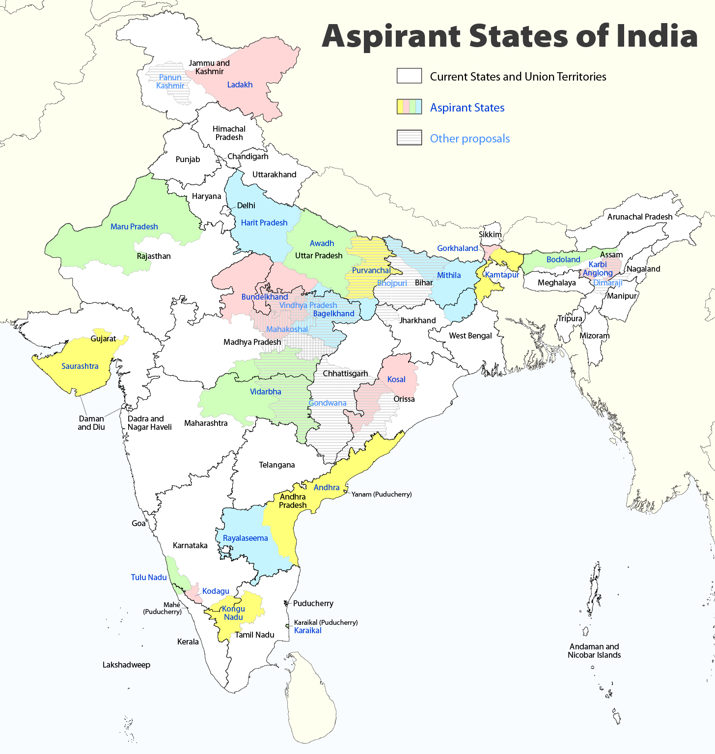
| Descripción |
Deutsch: Indiens Anwärterstaaten
English: Aspirant States of India |
| Data | |
| Fonte | Trabayu propiu |
| Autor | Maximilian Dörrbecker (Chumwa) |
| Permisu (Cómo reutilizar esti ficheru) |
Yo, el titular de los drechos d'autor d'esta obra, la espublizo baxo la siguiente llicencia: Este archivo se encuentra bajo la licencia Creative Commons Genérica de Atribución/Compartir-Igual 2.5.
Sie dürfen das Bild zu den folgenden Bedingungen nutzen:
|
| Otres versiones |
|

Historial del ficheru
Calca nuna fecha/hora pa ver el ficheru como taba daquella.
| Data/Hora | Miniatura | Dimensiones | Usuariu | Comentariu | |
|---|---|---|---|---|---|
| actual | 09:06 2 ago 2020 | | 1456 × 1535 (332 kB) | Chumwa | Reverted to version as of 21:03, 29 August 2018 (UTC) |
| 20:03 30 xnt 2020 |  | 1456 × 1535 (316 kB) | UT'sIndia | Reverted to version as of 15:15, 17 May 2013 (UTC) | |
| 21:03 29 ago 2018 |  | 1456 × 1535 (332 kB) | Chumwa | extended Tulu Nadu into Kerala | |
| 21:52 5 xun 2014 |  | 1456 × 1535 (332 kB) | Chumwa | borders of Rayalseema corrected | |
| 18:23 3 xun 2014 |  | 1456 × 1535 (332 kB) | Chumwa | borders of Mithila corrected | |
| 17:53 3 xun 2014 |  | 1456 × 1535 (331 kB) | Chumwa | Telangana now is an official state | |
| 15:16 17 may 2013 |  | 1456 × 1535 (316 kB) | Cromium | Removed large title; enlarged map key with slightly different wording | |
| 15:15 17 may 2013 |  | 1456 × 1535 (316 kB) | Cromium | Removed large title; enlarged map key with slightly different wording | |
| 22:32 2 xin 2012 |  | 1456 × 1535 (312 kB) | Chumwa | added some other aspirant states | |
| 21:16 2 xin 2012 |  | 1456 × 1535 (292 kB) | Chumwa | added a map key |
Usu del ficheru
Nun hai páxines qu'usen esti ficheru.
Usu global del ficheru
Estes otres wikis usen esti ficheru:
- Usu en bn.wikipedia.org
- Usu en de.wikipedia.org
- Usu en en.wikipedia.org
- Delhi
- Gondwana (India)
- Kodagu district
- Mithila (proposed Indian state)
- Awadh
- Vidarbha
- Bundelkhand
- Bagelkhand
- Tulu Nadu
- Rayalaseema
- Purvanchal
- Bodoland Territorial Region
- Karbi Anglong district
- Mahakoshal
- Kongu Nadu
- Cooch Behar district
- Gird, India
- Mara Autonomous District Council
- Tripura Tribal Areas Autonomous District Council
- Malabar District
- Gorkhaland movement
- Kamtapur
- Proposed states and union territories of India
- Autonomous administrative divisions of India
- Karaikal district
- Panun Kashmir
- Chakma Autonomous District Council
- Lai Autonomous District Council
- Khasi Hills Autonomous District Council
- Jaintia Hills Autonomous District Council
- Garo Hills Autonomous District Council
- Template:Proposed states and union territories of India
- Tulu Nadu state movement
- Kosal state movement
- User:AbhisheksinghWIKI/Law and Order(India)
- Gorkhaland Territorial Administration
- Tipraland
- Kalyana-Karnataka
- Sadar Hills
- West Karbi Anglong district
Ver más usos globales d'esti ficheru.