Ficheru:Roman.Britain.Romanisation.jpg
Tamañu d'esta previsualización: 566 × 599 pixels. Otres resoluciones: 227 × 240 pixels | 453 × 480 pixels | 725 × 768 pixels | 967 × 1024 pixels | 1934 × 2048 pixels | 3000 × 3176 pixels.
Ficheru orixinal (3000 × 3176 píxels, tamañu de ficheru: 924 kB, triba MIME: image/jpeg)
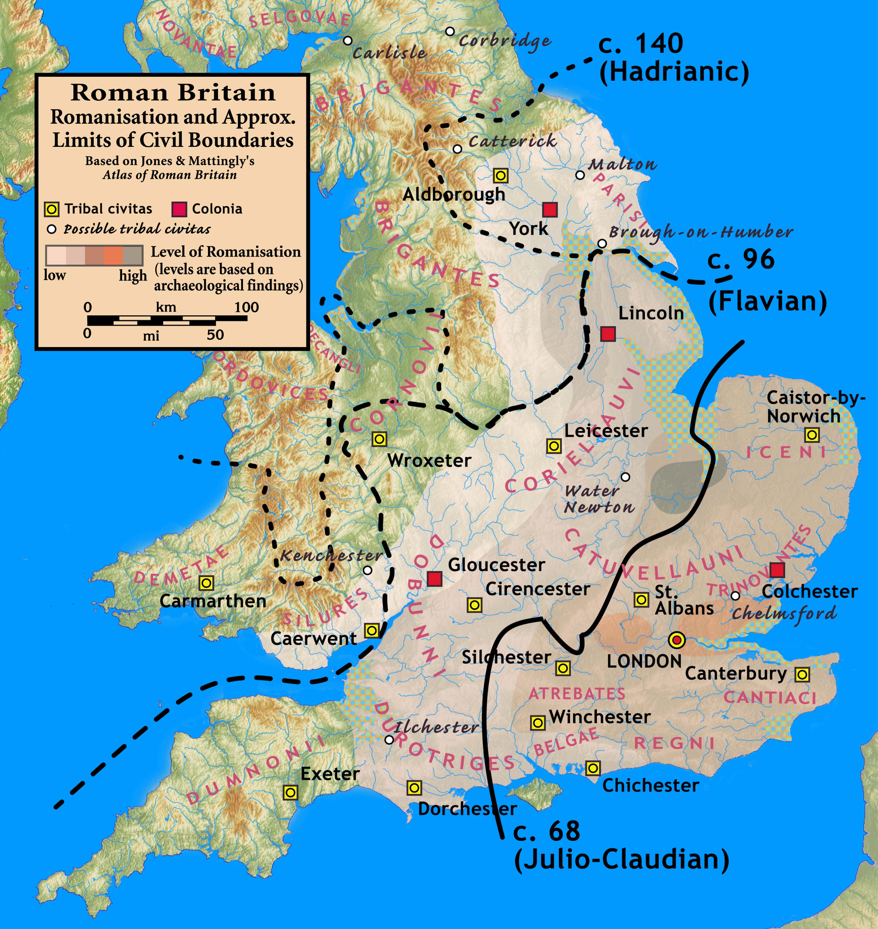
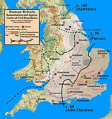
| Descripción | Roman Britain — Levels of Romanisation and Approximate Limits of Civil Boundaries |
| Data | |
| Fonte |
Based on Jones & Mattingly's Atlas of Roman Britain (ISBN 978-1-84217-06700, 1990, reprinted 2007) — the source is cited in the image legend — Approximate civil boundaries, civitates, and coloniae are given on page 154. Levels of Romanisation ("boundaries of acculturation" with levels from "high density" to "low density" in the text) are given on page 151, with the authors citing it as a computer-generated map based on data contained in the standard Ordnance Survey map of Roman Britain. |
| Autor | my work |
Yo, el titular de los drechos d'autor d'esta obra, la espublizo baxo la siguiente llicencia:
Esti ficheru ta disponible baxo la llicencia Creative Commons Reconocimientu-Compartir igual 3.0 xenérica.
- Ye llibre:
- pa compartir – pa copiar, distribuir y comunicar públicamente la obra
- pa remezclar – p'adautar la obra
- Baxo les condiciones siguientes:
- reconocimientu – Tienes de dar el créitu apropiáu, apurrir un enllaz a la llicencia ya indicar si realizasti dalgún cambéu. Puedes faelo de cualquier mou razonable ,pero non de manera que suxera l'encontu del autor pa ti o pal usu que faigas.
- compartir igual – Si entemeces, tresformes o te bases nesti material, tienes de distribuir les tos contribuciones baxo la mesma llicencia o una compatible cola orixinal.
Historial del ficheru
Calca nuna fecha/hora pa ver el ficheru como taba daquella.
| Data/Hora | Miniatura | Dimensiones | Usuariu | Comentariu | |
|---|---|---|---|---|---|
| actual | 01:12 9 set 2010 | | 3000 × 3176 (924 kB) | Notuncurious | {{Information |Description= Roman Britain — Levels of Romanisation and Approximate Limits of Civil Boundaries |Source=Based on Jones & Mattingly's ''Atlas of Roman Britain'' (ISBN 978-1-84217-06700, 1990, reprinted 2007) — the source is cited |
Usu del ficheru
La páxina siguiente usa esti ficheru:
Usu global del ficheru
Estes otres wikis usen esti ficheru:
- Usu en af.wikipedia.org
- Usu en ar.wikipedia.org
- Usu en bn.wikipedia.org
- Usu en ca.wikipedia.org
- Usu en en.wikipedia.org
- Usu en es.wikipedia.org
- Usu en fa.wikipedia.org
- Usu en fr.wikipedia.org
- Usu en fy.wikipedia.org
- Usu en hr.wikipedia.org
- Usu en id.wikipedia.org
- Usu en it.wikipedia.org
- Usu en ja.wikipedia.org
- Usu en ms.wikipedia.org
- Usu en nl.wikipedia.org
- Usu en nn.wikipedia.org
- Usu en no.wikipedia.org
- Usu en ro.wikipedia.org
- Usu en ru.wikipedia.org
- Usu en sh.wikipedia.org
- Usu en tr.wikipedia.org
- Usu en uk.wikipedia.org
- Usu en zh.wikipedia.org