Ficheru:Sahel Map-Africa rough.svg

Tamañu de la vista previa PNG d'esti ficheru SVG: 800 × 370 pixels. Otres resoluciones: 320 × 148 pixels | 640 × 296 pixels | 1024 × 474 pixels | 1280 × 592 pixels | 2560 × 1184 pixels | 1228 × 568 pixels.
Ficheru orixinal (ficheru SVG, 1228 × 568 píxels nominales, tamañu de ficheru: 711 kB)
Resume
| Descripción |
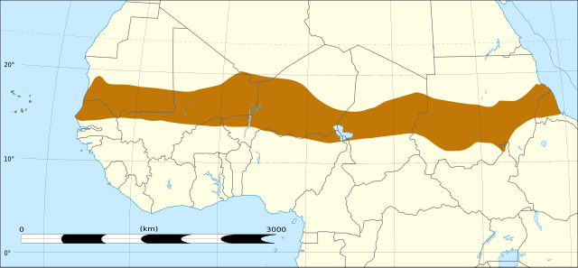
English: Map of Africa, with the Sahel highlighted in orange.
This is roughly the African land area between the lines of 200mm (north) and 600mm (south) mean 20th century annual rainfall. This is limited to land areas directly to the south of the Sahara desert and including the islands of Cape Verde, but not including other areas in Africa with the same rainfall statistics. This is one, but not the only, definition of the Sahel region. |
| Data | |
| Fonte | Africa location map without rivers.svg |
| Autor |
|
Llicencia
Este archivo está disponible bajo la licencia Creative Commons Attribution-Share Alike 4.0 International.
- Ye llibre:
- pa compartir – pa copiar, distribuir y comunicar públicamente la obra
- pa remezclar – p'adautar la obra
- Baxo les condiciones siguientes:
- reconocimientu – Tienes de dar el créitu apropiáu, apurrir un enllaz a la llicencia ya indicar si realizasti dalgún cambéu. Puedes faelo de cualquier mou razonable ,pero non de manera que suxera l'encontu del autor pa ti o pal usu que faigas.
- compartir igual – Si entemeces, tresformes o te bases nesti material, tienes de distribuir les tos contribuciones baxo la mesma llicencia o una compatible cola orixinal.
Historial del ficheru
Calca nuna fecha/hora pa ver el ficheru como taba daquella.
| Data/Hora | Miniatura | Dimensiones | Usuariu | Comentariu | |
|---|---|---|---|---|---|
| actual | 18:00 21 avi 2017 | | 1228 × 568 (711 kB) | Rowanwindwhistler | User created page with UploadWizard |
Usu del ficheru
Les páxines siguientes usen esti ficheru:
Usu global del ficheru
Estes otres wikis usen esti ficheru:
- Usu en de.wikipedia.org
- Usu en es.wikipedia.org
- Usu en sv.wikibooks.org