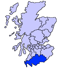
Ficheru:ScotlandDumfriesGalloway.png
ScotlandDumfriesGalloway.png (200 × 230 píxels, tamañu de ficheru: 4 kB, triba MIME: image/png)
Historial del ficheru
Calca nuna fecha/hora pa ver el ficheru como taba daquella.
| Data/Hora | Miniatura | Dimensiones | Usuariu | Comentariu | |
|---|---|---|---|---|---|
| actual | 21:31 17 may 2005 |  | 200 × 230 (4 kB) | Voyager | Dumfries and Galloway unitary council Slightly edited version of a map drawn by Morwen {{GFDL}} Category:Maps of Scottish unitary councils |
Usu del ficheru
Les páxines siguientes usen esti ficheru:
Usu global del ficheru
Estes otres wikis usen esti ficheru:
- Usu en be.wikipedia.org
- Usu en bg.wikipedia.org
- Usu en ca.wikipedia.org
- Usu en cy.wikipedia.org
- Usu en de.wikipedia.org
- Usu en de.wikivoyage.org
- Usu en en.wikipedia.org
- Usu en eu.wikipedia.org
- Dumfries eta Galloway
- Dumfries
- Lankide:Euskaldunaa
- Stranraer
- Annan
- Txantiloi:Dumfries eta Galloway
- Wikiproiektu:Irlanda, Gales eta Eskoziako udalerriak
- Applegarthtown
- Inch (Dumfries eta Galloway)
- Bladnoch (Wigtownshire)
- Cairnryan
- Glasserton
- Glenluce
- Kirkcolm
- Kirkmaiden
- Leswalt
- Mochrum
- New Luce
- Newton Stewart
- Old Luce
- Penninghame
- Port William (Dumfries eta Galloway)
- Portpatrick
- Sandhead
- Sorbie
- Stoneykirk
- Wigtown
- Whithorn
- Kirkcowan
- Kirkinner
- Anwoth
- Caerlaverock
- Barburgh Mill
- Brow (Dumfries eta Galloway)
- Dalgarnock
- Dryfesdale
Ver más usos globales d'esti ficheru.

