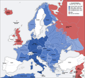
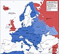
Ficheru:Second world war europe 1941-1942 map en.png

Ficheru orixinal(1090 × 1000 píxels, tamañu de ficheru: 216 kB, triba MIME: image/png)

Esti ficheru ye de Wikimedia Commons y puen usalu otros proyeutos. La descripción de la páxina de descripción del ficheru s'amuesa darréu.

Esta imagen debería volverse a crear como imágenes vectoriales SVG. Esto proporciona muchas ventajas, véase Commons:Media for cleanup (en inglés) para más información. Si ya hay una versión SVG de esta imagen disponible, por favor súbala a Commons. Tras subirla, reemplace esta plantilla con la plantilla {{vector version available|nuevo nombre de imagen.svg}} en esta imagen.
Mapas de la historia de Europa
BCE
aC

Weichselian ice age (c. 113,000–9700) · Neolithic expansion (c. 7000–4500) · Middle Neolithic (c. 4500–4000) · Late Neolithic (c. 4000–3000) · Copper Age – Corded Ware culture (c. 2900–2350) · Copper Age – Bellbeaker culture (c. 2800–1800) · Early Bronze Age – Unetice culture (c. 2300–1600) · Late Bronze Age – Urnfield culture (c. 1300—750) · Migrations (c. 1000–100) · Hallstatt & La Tène cultures (c. 800–100) · Roman Republic (510–40) · 220 · 218 · 200 · 201–100 · 58 · 49 · 39 · 30 BCE–6 CE


CE
dC

14 · 14–37 · 60 · 60 · 69 · 80 · Migrations 100–500 · 117 · 117 · 125 · Migrations 150–774 · Economy 180 · 271 · 293–305 · 337 · 395 · c. 395 · 400 · 400 · 450 · 457–61 · 476 · 480 · Franks 481–814 · Early Slavs 500–700 · 500 · 526 · 526–600 · Christianisation to 600 · c. 550 · 650 · Pontic Steppe 650 · 665 · 800 · Vikings 800–1050 · 814 · 843–70 · 850 · 900 · 912 · 998 · 1000 · 1000 · 1054 · 1092 · First Crusade 1095–99 · 1097 · 1135 · 1142 · 1147–49 · 1190 · 1190 · 1250 · c. 1250 · 1301-1400 · 1301-1400 · 1328 · 1345 · Black Plague 1347–51 · 1360 · 1400 · Trade routes c. 1400 · 1430 · 1470 · 1490 · 1492 · 1500 · 1519 · 1550 · 1560 · Religion 1560 · Religion 1600 · Religion 1618 · 1618–48 · 1648 · 1683 · 1700 · 1701 · 1708 · 1714 · 1721 · 1725–30 · 1739–1740 · 1740 · 1748–66 · 1783–1792 · 1787 · 1787 · 1789 · 1799 · 1812 · 1812 · 1812 · 1812 · 1813 · 1815 · 1815 · 1815 · 1818 · Ottoman Empire 1830–1923 · 1848–49 · 1861 · 1867 · 1871 · 1878 · 1890 · 1905 · 1911 · 1914 · 1914 · 1919 · 1919–29 · 1923 · 1929 · 1930 · 1940 · 1941–42 · 1942–45 · Cold War 1947–91 · 1950 · 1993–2006 · 2006 to date

(this template: · view · discuss )

Resume

Annotations
InfoField
This image is annotated: View the annotations at Commons
Descripción
Deutsch: Karte der vom Deutschen Reich besetzten Gebiete und der Kriegsfronten im Zweiten Weltkrieg, 1941/42.
English: A map of German front of the Second World War circa 1941-1942.
Ελληνικά: Εδαφικές κατακτήσεις του Ράιχ
Español: Conquistas territoriales del Reich
Data Original Image: 17 April 2005
Derivative Image: 22 December 2005
Fonte Este archivo deriva de: Second world war europe 1941-1942 map de.png
Autor Original Author: User:San Jose
Derivative Author: User:ArmadniGeneral
Permisu
(Cómo reutilizar esti ficheru)
This image is a translation of the original, created and released under the terms of the GNU Free Documentation License.
Otres versiones

Obras derivadas de ésta:  Großdeutsches Reich-europe.png [editar]

Llicencia

GNU head Autorízase la copia, distribución y/o cambéu d'esti documentu baxo los términos de la Llicencia de documentación llibre GNU, versión 1.2 o cualesquier otra que nel futuru espublice la Free Software Foundation; ensin seiciones invariables, testos de portada, nin testos de contraportada. S'inclúi una copia de la llicencia na seición titulada GNU Free Documentation License.
w:es:Creative Commons
reconocimientu compartir igual
Esti ficheru ta disponible baxo la llicencia Creative Commons Reconocimientu-Compartir igual 3.0 xenérica.
Ye llibre:
  • pa compartir – pa copiar, distribuir y comunicar públicamente la obra
  • pa remezclar – p'adautar la obra
Baxo les condiciones siguientes:
  • reconocimientu – Tienes de dar el créitu apropiáu, apurrir un enllaz a la llicencia ya indicar si realizasti dalgún cambéu. Puedes faelo de cualquier mou razonable ,pero non de manera que suxera l'encontu del autor pa ti o pal usu que faigas.
  • compartir igual – Si entemeces, tresformes o te bases nesti material, tienes de distribuir les tos contribuciones baxo la mesma llicencia o una compatible cola orixinal.
Esta etiqueta de llicencia s'amestó a esti ficheru como parte del anovamientu de la llicencia GFDL.

Pies

Añade una explicación corta acerca de lo que representa este archivo
This map represents Europe in 1941-1942

Elementos representados en este archivo

representa a

tipo de archivo español

image/png

Historial del ficheru

Calca nuna fecha/hora pa ver el ficheru como taba daquella.

Data/HoraMiniaturaDimensionesUsuariuComentariu
actual16:20 5 ago 2020Miniatura de la versión a fecha de 16:20 5 ago 20201090 × 1000 (216 kB)Claude ZygielDistinguished statutes
01:00 28 xnt 2018Miniatura de la versión a fecha de 01:00 28 xnt 20181090 × 1000 (184 kB)JeffyPShrinking file size
08:06 16 feb 2009Miniatura de la versión a fecha de 08:06 16 feb 20091090 × 1000 (214 kB)Guinnog{{Information |Description=better titles |Source=*File:Second_world_war_europe_1941-1942_map_en.png |Date=2009-02-16 08:05 (UTC) |Author=*File:Second_world_war_europe_1941-1942_map_en.png: Sir Lothar *derivative work: ~~~ |Permission=see below
00:22 11 abr 2008Miniatura de la versión a fecha de 00:22 11 abr 20081090 × 1000 (208 kB)Sir Lothar
05:36 21 avi 2005Miniatura de la versión a fecha de 05:36 21 avi 20051090 × 1000 (221 kB)ArmadniGeneralA map of the Eastern front of the Second World War circa 1941-1942. The original German-language map was created by User:San Jose on 17 April 2005. It can be found here: Image:Second world war europe 1941-1942 map de.png. This image is a translat

La páxina siguiente usa esti ficheru:

Usu global del ficheru

Estes otres wikis usen esti ficheru:

Ver más usos globales d'esti ficheru.

Metadatos