Ficheru orixinal(724 × 949 píxels, tamañu de ficheru: 73 kB, triba MIME: image/png)

Esti ficheru ye de Wikimedia Commons y puen usalu otros proyeutos. La descripción de la páxina de descripción del ficheru s'amuesa darréu.

Resume

Descripción
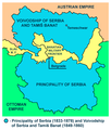
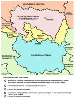
English: Two autonomous historical territories named Serbia: 1. Principality of Serbia within Ottoman Empire (1833-1878), and 2. Voivodeship of Serbia and Banat of Temeschwar within Austrian Empire (1849-1860)
Српски / srpski: Две аутономне историјске територије са називом Србија: 1. Кнежевина Србија у оквиру Отоманског царства (1833-1878) и 2. Војводство Србија и Тамишки Банат у оквиру Аустријског царства (1849-1860)
Data
Fonte
Atlas This map has been uploaded by Electionworld from en.wikipedia.org to enable the Wikimedia Atlas of the World . Original uploader to en.wikipedia.org was PANONIAN, known as PANONIAN at en.wikipedia.org. Electionworld is not the creator of this map. Licensing information is below.
Autor Self-made map by PANONIAN
Permisu
(Cómo reutilizar esti ficheru)
Public domain L'autor d'esta obra, PANONIAN, la lliberó como dominiu públicu. Esto s'aplica nel mundu ensembre.

En dellos países seique esto nun seya posible llegalmente; nesti casu:
PANONIAN da a cualesquier persona permisu pa usar esta obra pa cualesquier propósitu, ensin denguna condición, menos si eses condiciones requierense pola llei.

Otres versiones Serbian language Cyrillic script version Serbian language Latin script version

References

Published references:

  • The Times History of Europe, Times Books, 2002.
  • Sima M. Ćirković, Srbi među evropskim narodima, Beograd, 2004.
  • Dr Tomislav Bogavac, Nestajanje Srba, Niš, 1994.
  • Dragomir Jankov, Vojvodina - propadanje jednog regiona, Novi Sad, 2004.
  • Istorijski atlas, Zavod za udžbenike i nastavna sredstva - Zavod za kartografiju "Geokarta", Beograd, 1999.
  • Školski istorijski atlas, Zavod za izdavanje udžbenika Socijalističke Republike Srbije, Beograd, 1970.
  • Peter Rokai - Zoltan Đere - Tibor Pal - Aleksandar Kasaš, Istorija Mađara, Beograd, 2002.
  • Lazo M. Kostić, Srpska Vojvodina i njene manjine, Novi Sad, 1999.
  • Drago Njegovan, Prisajedinjenje Vojvodine Srbiji, Novi Sad, 2004.
  • Čedomir Popov - Jelena Popov, Autonomija Vojvodine - srpsko pitanje, Sremski Karlovci, 2000.
  • Dr Dušan J. Popović, Srbi u Vojvodini, knjiga 3, Novi Sad, 1990.
  • J. H. Šviker, Politička istorija Srba u Ugarskoj, Novi Sad - Beograd, 1998.
  • Sigfrid Kaper, Srpski pokret u južnoj Ugarskoj 1848-1849, Beograd - Valjevo, 1996.
  • Dimitrije Boarov, Politička istorija Vojvodine, Novi Sad, 2001.
  • Dejan Mikavica, Srpska Vojvodina u Habsburškoj monarhiji 1690-1920, Novi Sad, 2005.
  • Dr Milenko Palić, Srbi u Mađarskoj - Ugarskoj do 1918, Novi Sad, 1995.
  • Drago Njegovan, Srpska Vojvodina, Enciklopedija Novog Sada, knjiga 26, Novi Sad, 2005.
  • Istorija Vojvodine, Enciklopedija Novog Sada, sveska 5, Novi Sad, 1996.
  • Vladimir Ćorović, Ilustrovana istorija Srba, knjiga peta, Beograd, 2006.
  • Vasilije Krestić, Iz prošlosti Srema, Bačke i Banata, Beograd, 2003.
  • Slavko Gavrilović, Srbi u Habsburškoj Monarhiji (1792-1849), Novi Sad, 1994.
  • Milan Tutorov, Banatska rapsodija, Novi Sad, 2001.
  • Jovan M. Pejin, Iz prošlosti Kikinde, Kikinda, 2000.
  • Rodoljub Malenčić, Miletić, Novi Sad, 1996.
  • Čedomir Popov - Slavko Gavrilović, Evropska revolucija i srpski pokret 1848-1849, Beograd - Novi Sad, 1997.

Internet references:

Pies

Añade una explicación corta acerca de lo que representa este archivo

Elementos representados en este archivo

representa a

tipo de archivo español

image/png

Historial del ficheru

Calca nuna fecha/hora pa ver el ficheru como taba daquella.

Data/HoraMiniaturaDimensionesUsuariuComentariu
actual14:17 8 och 2013Miniatura de la versión a fecha de 14:17 8 och 2013724 × 949 (73 kB)PANONIANaesthetics
10:20 24 avi 2009Miniatura de la versión a fecha de 10:20 24 avi 2009717 × 944 (73 kB)PANONIANaesthetics
18:50 1 xun 2009Miniatura de la versión a fecha de 18:50 1 xun 2009717 × 944 (73 kB)PANONIAN
22:19 13 feb 2008Miniatura de la versión a fecha de 22:19 13 feb 2008522 × 557 (28 kB)Imbris~commonswikiThe image must be free of POV. The image I'am proposing is using different colours for the Principality of Serbia and Serb Voivodship and Tamiš Banate.
11:58 1 may 2007Miniatura de la versión a fecha de 11:58 1 may 2007522 × 613 (70 kB)Tene~commonswikiOptimised (0)
21:40 21 avi 2006Miniatura de la versión a fecha de 21:40 21 avi 2006522 × 613 (87 kB)Electionworld{{ew|en|PANONIAN}} Self-made map by PANONIAN {{PD-user|PANONIAN}} Category:Maps of Serbia

La páxina siguiente usa esti ficheru:

Usu global del ficheru

Estes otres wikis usen esti ficheru: