Ficheru:Shetland UK relief location map.jpg

Tamañu d'esta previsualización: 315 × 599 pixels. Otres resoluciones: 126 × 240 pixels | 252 × 480 pixels | 404 × 768 pixels | 538 × 1024 pixels | 1999 × 3802 pixels.
Ficheru orixinal (1999 × 3802 píxels, tamañu de ficheru: 505 kB, triba MIME: image/jpeg)
| Descripción |
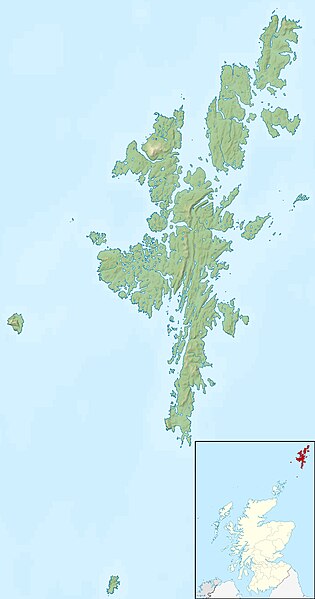
Relief map of the Shetland Islands, UK. Equirectangular map projection on WGS 84 datum, with N/S stretched 200% Geographic limits:
|
| Data | |
| Fonte |
|
| Autor | Nilfanion, created using Ordnance Survey data |
| Permisu (Cómo reutilizar esti ficheru) |
Esti ficheru ta disponible baxo la llicencia Creative Commons Reconocimientu-Compartir igual 3.0 xenérica. Reconocimientu: Contains Ordnance Survey data © Crown copyright and database right
|
| Otres versiones | File:Shetland UK blank map.svg - Blank map |
Historial del ficheru
Calca nuna fecha/hora pa ver el ficheru como taba daquella.
| Data/Hora | Miniatura | Dimensiones | Usuariu | Comentariu | |
|---|---|---|---|---|---|
| actual | 12:29 30 pay 2011 | | 1999 × 3802 (505 kB) | Nilfanion | {{Information |Description=Relief map of the Shetland Islands, UK. Equirectangular map projection on WGS 84 datum, with N/S stretched 200% Geographic limits: *West: 2.15W *East: 0.70W *North: 60.88N *South: 59.50N |Source=[[w:Ordn |
Usu del ficheru
La páxina siguiente usa esti ficheru:
Usu global del ficheru
Estes otres wikis usen esti ficheru:
- Usu en ar.wikipedia.org
- Usu en bg.wikipedia.org
- Usu en ca.wikipedia.org
- Usu en ceb.wikipedia.org
- Usu en da.wikipedia.org
- Usu en de.wikipedia.org
- Usu en de.wikivoyage.org
- Usu en en.wikipedia.org
Ver más usos globales d'esti ficheru.