Ficheru:ShizuokaMapCurrent.png

Tamañu d'esta previsualización: 800 × 500 pixels. Otres resoluciones: 320 × 200 pixels | 640 × 400 pixels | 1024 × 640 pixels | 1281 × 801 pixels.
Ficheru orixinal (1281 × 801 píxels, tamañu de ficheru: 30 kB, triba MIME: image/png)
Resume
| Descripción |
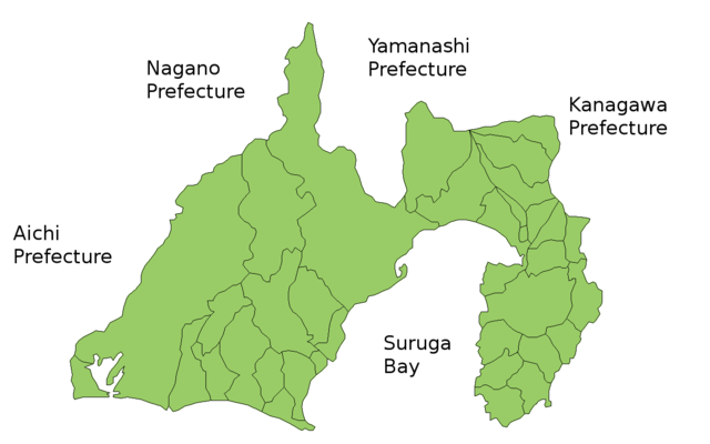
Map of Shizuoka Prefecture, Japan. Thanks to Aoki Shigenobu and [1]. Colors from Image:TokyoMapCurrent.png by User:Fg2. |
| Data | 19 de xunetu de 2006 (fecha original de carga) |
| Fonte | No machine-readable source provided. Own work assumed (based on copyright claims). |
| Autor | No machine-readable author provided. Akanemoto~commonswiki assumed (based on copyright claims). |
Llicencia
| Yo, el titular de los drechos d'autor d'esta obra, la llibero como dominiu públicu. Esto s'aplica nel mundu ensembre. En dellos países seique esto nun seya posible llegalmente; nesti casu: Doi a cualesquier persona permisu pa usar esta obra pa cualesquier propósitu, ensin denguna condición, menos si eses condiciones requierense pola llei. |
Historial del ficheru
Calca nuna fecha/hora pa ver el ficheru como taba daquella.
| Data/Hora | Miniatura | Dimensiones | Usuariu | Comentariu | |
|---|---|---|---|---|---|
| actual | 04:34 30 mar 2021 | | 1281 × 801 (30 kB) | AichiWikiFixer | update |
| 22:12 28 set 2011 |  | 1281 × 801 (42 kB) | Haaninjo | Mergers into Fujieda, Fujinomiya and Kosai | |
| 04:02 1 pay 2008 |  | 1281 × 801 (43 kB) | Alberth2 | ||
| 17:38 19 xnt 2006 |  | 1281 × 801 (42 kB) | Akanemoto~commonswiki | Map of Shizuoka Prefecture, Japan. Thanks to Aoki Shigenobu and [http://aoki2.si.gunma-u.ac.jp/map/map.html]. Colors from Image:TokyoMapCurrent.png by User:Fg2. Category:Maps of Shizuoka prefecture Category:Maps in English |
Usu del ficheru
Nun hai páxines qu'usen esti ficheru.
Usu global del ficheru
Estes otres wikis usen esti ficheru:
- Usu en az.wikipedia.org
- Usu en ckb.wikipedia.org
- Usu en cs.wikipedia.org
- Usu en eu.wikipedia.org
- Usu en fi.wikipedia.org
- Usu en hu.wikipedia.org
- Usu en jv.wikipedia.org
- Usu en lt.wikipedia.org
- Usu en ms.wikipedia.org
- Usu en no.wikipedia.org
- Usu en pl.wikipedia.org
- Usu en ru.wikipedia.org