Ficheru:Spitsbergen labelled.png
Nun ta disponible con mayor resolución.
Spitsbergen_labelled.png (451 × 446 píxels, tamañu de ficheru: 161 kB, triba MIME: image/png)
Resume
| Descripción |
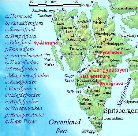
English: Map detailing the marine features of Spitsbergen in the Svalbard archipelago. Settlements and mountains are indicated and labelled. See also Image:Spitsbergen mountains and marine features labelled.png. Locations were labelled mainly based on detailed maps from svalbard-images.com (sample of south Spitsbergen linked), cross-referenced with other map sources where possible. Norwegian Polar Institute figures were used for mountain names and heights, which are given in meters above sea level. |
| Data | 25 de xunetu de 2006 (fecha original de carga) |
| Fonte | No machine-readable source provided. Own work assumed (based on copyright claims). |
| Autor | No machine-readable author provided. TheGrappler assumed (based on copyright claims). |
Llicencia
DEMIS World Map Server archive copy at the Wayback Machine generated this map from Public Domain sources. DEMIS does not claim any rights over the resultant image ([1] archive copy at the Wayback Machine). Alterations, including the addition of settlements and captions, were performed on 24 July 2006 by User:TheGrappler, the uploader, who releases all associated rights.
| Yo, el titular de los drechos d'autor d'esta obra, la llibero como dominiu públicu. Esto s'aplica nel mundu ensembre. En dellos países seique esto nun seya posible llegalmente; nesti casu: Doi a cualesquier persona permisu pa usar esta obra pa cualesquier propósitu, ensin denguna condición, menos si eses condiciones requierense pola llei. |
Esta imagen está en el dominio público porque proviene del sitio https://www.demis.nl/products/web-map-server/examples/ y fue publicada por el titular de los derechos de autor. derechos de autor. Se otorga permiso para copiar, distribuir y/o modificar este mapa ya que se basa en imágenes libres de derechos de autor de: www.demis.nl. Véase también el correo electrónico de aprobación en de.wp y y su aclaración.
|
| This work has been released into the public domain by its copyright holder, www.demis.nl. This applies worldwide. En dellos países seique esto nun seya posible llegalmente; nesti casu: www.demis.nl da a cualesquier persona permisu pa usar esta obra pa cualesquier propósitu, ensin denguna condición, menos si eses condiciones requierense pola llei.
|
Historial del ficheru
Calca nuna fecha/hora pa ver el ficheru como taba daquella.
| Data/Hora | Miniatura | Dimensiones | Usuariu | Comentariu | |
|---|---|---|---|---|---|
| actual | 09:23 26 xnt 2006 | | 451 × 446 (161 kB) | TheGrappler | More detail in South |
| 00:58 25 xnt 2006 |  | 451 × 446 (159 kB) | TheGrappler | Move "Albert I Land" label slightly, to avoid obscuring Magdalenefjorden | |
| 00:46 25 xnt 2006 |  | 451 × 446 (160 kB) | TheGrappler | == Summary == {{English}} Map detailing the marine features of Spitsbergen in the Svalbard archipelago. Settlements and mountains are indicated and labelled. See also Image:Spitsbergen mountains and marine features labelled.png. Locations were labell |
Usu del ficheru
Les páxines siguientes usen esti ficheru:
Usu global del ficheru
Estes otres wikis usen esti ficheru:
- Usu en af.wikipedia.org
- Usu en az.wikipedia.org
- Usu en bg.wikipedia.org
- Usu en ca.wikipedia.org
- Usu en ceb.wikipedia.org
- Usu en cv.wikipedia.org
- Usu en da.wikipedia.org
- Usu en de.wikipedia.org
- Usu en el.wikipedia.org
- Usu en en.wikipedia.org
- Spitsbergen
- Danes Island
- Isfjorden (Svalbard)
- Wijdefjorden
- Van Mijenfjorden
- Olav V Land
- Fairhaven (Svalbard)
- Bellsund
- Magdalenefjorden
- Recherche Fjord
- Forlandsundet
- Engelskbukta
- Amsterdam Island (Spitsbergen)
- Van Muydenbukta
- Van Keulenfjorden
- Krossfjorden
- Billefjorden
- Adventfjorden
- Grønfjorden
- Ekmanfjorden
- Moffen
- Sørkappøya
- Raudfjorden
Ver más usos globales d'esti ficheru.