Ficheru:Tribes of Sicily by 11th century BC.png
Nun ta disponible con mayor resolución.
Tribes_of_Sicily_by_11th_century_BC.png (659 × 438 píxels, tamañu de ficheru: 29 kB, triba MIME: image/png)

|
Esta imagen debería volverse a crear como imágenes vectoriales SVG. Esto proporciona muchas ventajas, véase Commons:Media for cleanup (en inglés) para más información. Si ya hay una versión SVG de esta imagen disponible, por favor súbala a Commons. Tras subirla, reemplace esta plantilla con la plantilla
{{vector version available|nuevo nombre de imagen.svg}} en esta imagen. |
Resume
| Descripción |
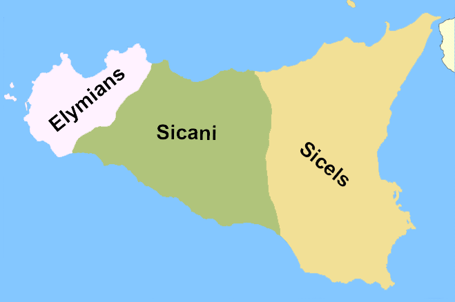
English: A rough reconstruction of the locations of the Elymians, Sicani and Sicels in Sicily around 11th century BC, before the arrival of the Phoenicians and the Greeks. Note from author: "This is a map I created which roughly depicts the location of the native Italic tribes of Sicily, no exact borders are known (as of October 2007) so this is to be taken in the context of rough areas. To devise this I have used the following informative sources[1][2][3] Version labelled in Esperanto can be reached at eo:Dosiero:Praaj triboj de Sicilio.png".
This is highly questionable. There may not even have been any "Sicels" on Sicily before the "arrival of the Phoenicians". The map is just pulled from thin air and has no relation to the 11th century. At best it shows the rough location of the three tribal groups around the 6th century.
Français : Localisation des différentes tribus en Sicile avant la colonisation grecque.
Español: Pueblos prerromanos de Sicilia: elimios (elymiī), sicanos (sicānī) y sículos (siculī). Mapa con la localización aproximada de las tribus siciliotas antes de la llegada de los griegos.
Русский: Схема расселения догреческих народов Сицилии (слева направо: элимцы, сиканы, сикулы). Схема расселения догреческих народов Сицилии (слева направо: элимцы, сиканы, сикулы). Территории племён на о. Сицилия к приходу греков. Схема расселения догреческих народов Сицилии (слева направо: элимцы, сиканы, сикулы).
Português: Os Sicanos habitavam o centro da Sicília.
Svenska: Folkslagen sikeler, elymer och sikaner: den ungefärliga utbredningen innan grekernas ankomst. Folkslagen sikeler, elymer och sikaner: den ungefärliga utbredningen innan grekernas ankomst. Folkslagen sikeler, elymer och sikaner: den ungefärliga utbredningen innan grekernas ankomst.
Català: Mapa de la situació dels sicans.
Norsk bokmål: En grovt kart over fordelingen av innfødte stammene på Sicilia i oldtiden. Et kart over Sicilia som grovt viser inndelingen av de tre folkeslagene.
Українська: Схема розселення догрецьких народів Сицилії (зліва направо: Еліми, Сікани, Сікули). Схема розселення догрецьких народів Сицилії (зліва направо: Елімці, Сікани, Сікули). Схема розселення догрецьких народів Сицилії (зліва направо: Елімці, Сікани, Сікули).
Čeština: Pravděpodobné rozmístění tří italických národů obývajících Sicílii.
Српски / srpski: Мапа положаја италских племена на Сицилији.
Lietuvių: Elymų žemės Sicilijoje. Sikanų žemės Sicilijoje.
العربية: خريطة تقريبية لانتشار الشعوب الصقلية القديمة. خريطة تقريبية لانتشار الشعوب الصقلية القديمة.
Hrvatski: Okvirna karta drevnih naroda na Siciliji. Karta položaja italskih plemena na Siciliji. Gruba karta drevnih sicilijansklih naroda. Okvirna karta drevnih naroda na Siciliji.
Eesti: Vanimad hõimud Sitsiilias.
Srpskohrvatski / српскохрватски: Okvirna karta drevnih naroda na Siciliji. Karta položaja italskih plemena na Siciliji. Gruba karta drevnih sicilijansklih naroda. Okvirna karta plemenske podjele Sicilije prije dolaska Grka.
Sicilianu: La Sicilia agghiri lu 1000 a.C. (Sicels significa Siculi nto ngrisi). |
| Data | |
| Fonte | Self-published work by Soprani |
| Autor | Soprani |
| Otres versiones |
|


![[2]](http://www.conigliofamily.com/images/SicilyMap.jpg)
![[3]](https://en.wikipedia.org/wiki/Image:Sicily_elymians.png)
Llicencia
Yo, el titular de los drechos d'autor d'esta obra, la espublizo baxo les siguientes llicencies:

|
Autorízase la copia, distribución y/o cambéu d'esti documentu baxo los términos de la Llicencia de documentación llibre GNU, versión 1.2 o cualesquier otra que nel futuru espublice la Free Software Foundation; ensin seiciones invariables, testos de portada, nin testos de contraportada. S'inclúi una copia de la llicencia na seición titulada GNU Free Documentation License. |
| Esti ficheru ta disponible baxo la llicencia Creative Commons Reconocimientu-Compartir igual 3.0 xenérica. | ||
| ||
| Esta etiqueta de llicencia s'amestó a esti ficheru como parte del anovamientu de la llicencia GFDL. |
Pues seleicionar la llicencia que prefieras.
Historial del ficheru
Calca nuna fecha/hora pa ver el ficheru como taba daquella.
| Data/Hora | Miniatura | Dimensiones | Usuariu | Comentariu | |
|---|---|---|---|---|---|
| actual | 18:23 7 och 2007 | | 659 × 438 (29 kB) | Soprani~commonswiki | This is a map I created which roughly depicts the location of the native Italic tribes of Sicily, no exact borders are known (as of October 2007) so this is to be taken in the context of rough areas. To devise this I have used the following informative so |
Usu del ficheru
La páxina siguiente usa esti ficheru:
Usu global del ficheru
Estes otres wikis usen esti ficheru:
- Usu en ar.wikipedia.org
- Usu en az.wikipedia.org
- Usu en cs.wikipedia.org
- Usu en de.wikipedia.org
- Usu en en.wikipedia.org
- Usu en et.wikipedia.org
- Usu en fr.wikipedia.org
- Usu en hr.wikipedia.org
- Usu en hy.wikipedia.org
- Usu en ja.wikipedia.org
- Usu en lt.wikipedia.org
- Usu en nl.wikipedia.org
- Usu en no.wikipedia.org
- Usu en pl.wikipedia.org
- Usu en scn.wikipedia.org
- Usu en sh.wikipedia.org
- Usu en simple.wikipedia.org
- Usu en sr.wikipedia.org
- Usu en sv.wikipedia.org
- Usu en uk.wikipedia.org
- Usu en www.wikidata.org
- Usu en zh.wikipedia.org