Ficheru:UsedomWolin.png
Nun ta disponible con mayor resolución.
UsedomWolin.png (543 × 419 píxels, tamañu de ficheru: 12 kB, triba MIME: image/png)
Resume
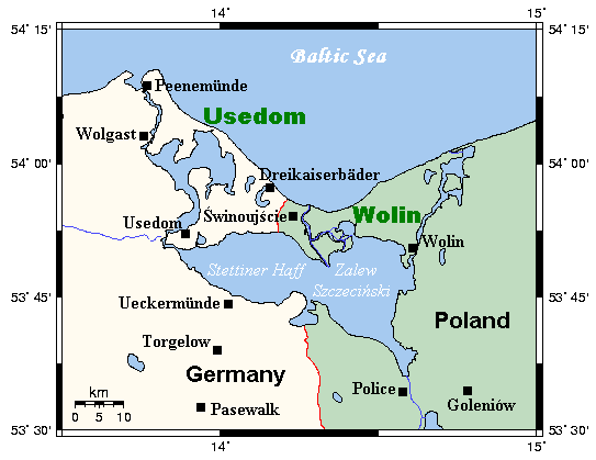
| Descripción | A map of the islands of Usedom and Wolin and environs, Germany/Poland. This map's source is here, with the uploader's modifications, and the GMT homepage says that the tools are released under the GNU General Public License. |
| Data | 13 de marzu de 2006 (fecha original de carga) |
| Fonte | Transferido desde en.wikipedia a Commons. |
| Autor | Kelisi de Wikipedia en inglés |
Llicencia
Kelisi na Wikipedia n'inglés, titular de los drechos d'autor d'esta obra, la espubliza baxo la siguiente llicencia:

|
Autorízase la copia, distribución y/o cambéu d'esti documentu baxo los términos de la Llicencia de documentación llibre GNU, versión 1.2 o cualesquier otra que nel futuru espublice la Free Software Foundation; ensin seiciones invariables, testos de portada, nin testos de contraportada. S'inclúi una copia de la llicencia na seición titulada GNU Free Documentation License. Suxetu a disclaimer. |
Rexistru de xubíes orixinal
Aquí se muestra la página de descripción original. Los siguientes nombres de usuario se refieren a en.wikipedia.
- 2006-03-13 21:35 Kelisi 543×419×8 (12000 bytes) A map of the islands of Usedom and Wolin and environs, Germany/Poland. This map's source is [http://www.aquarius.geomar.de/omc/make_map.html here], with the uploader's modifications, and the [http://gmt.soest.hawaii.edu/ GMT homepage] says that the tools
Historial del ficheru
Calca nuna fecha/hora pa ver el ficheru como taba daquella.
| Data/Hora | Miniatura | Dimensiones | Usuariu | Comentariu | |
|---|---|---|---|---|---|
| actual | 16:43 30 may 2007 | | 543 × 419 (12 kB) | Frokor | {{Information |Description=A map of the islands of Usedom and Wolin and environs, Germany/Poland. This map's source is [http://www.aquarius.geomar.de/omc/make_map.html here], with the uploader's modifications, and the [http://gmt.soest.hawaii.edu/ GMT hom |
Usu del ficheru
La páxina siguiente usa esti ficheru:
Usu global del ficheru
Estes otres wikis usen esti ficheru:
- Usu en ar.wikipedia.org
- Usu en be.wikipedia.org
- Usu en br.wikipedia.org
- Usu en ca.wikipedia.org
- Usu en da.wikipedia.org
- Usu en en.wikipedia.org
- Usu en es.wikipedia.org
- Usu en fi.wikipedia.org
- Usu en fr.wikipedia.org
- Usu en hr.wikipedia.org
- Usu en hu.wikipedia.org
- Usu en id.wikipedia.org
- Usu en it.wikipedia.org
- Usu en ja.wikipedia.org
- Usu en ko.wikipedia.org
- Usu en lt.wikipedia.org
- Usu en mk.wikipedia.org
- Usu en nn.wikipedia.org
- Usu en no.wikipedia.org
- Usu en pl.wikipedia.org
- Usu en pl.wiktionary.org
- Usu en pt.wikipedia.org
- Usu en ro.wikipedia.org
- Usu en ru.wikipedia.org
- Usu en sk.wikipedia.org
- Usu en sv.wikipedia.org
- Usu en vi.wikipedia.org