Ficheru:WaroftheAustrianSuccession.png

Tamañu d'esta previsualización: 800 × 370 pixels. Otres resoluciones: 320 × 148 pixels | 640 × 296 pixels | 1357 × 628 pixels.
Ficheru orixinal (1357 × 628 píxels, tamañu de ficheru: 27 kB, triba MIME: image/png)
Resume
| Descripción |
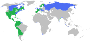
English: Locator map of the competing sides of the War of the Austrian Succession before outset of the war (1740).
|
| Data | |
| Fonte | Trabayu propiu |
| Autor | Gabagool |
Llicencia
Yo, el titular de los drechos d'autor d'esta obra, la espublizo baxo la siguiente llicencia:
Este archivo se encuentra bajo la licencia Creative Commons Atribución 3.0 Unported.
- Ye llibre:
- pa compartir – pa copiar, distribuir y comunicar públicamente la obra
- pa remezclar – p'adautar la obra
- Baxo les condiciones siguientes:
- reconocimientu – Tienes de dar el créitu apropiáu, apurrir un enllaz a la llicencia ya indicar si realizasti dalgún cambéu. Puedes faelo de cualquier mou razonable ,pero non de manera que suxera l'encontu del autor pa ti o pal usu que faigas.
Historial del ficheru
Calca nuna fecha/hora pa ver el ficheru como taba daquella.
| Data/Hora | Miniatura | Dimensiones | Usuariu | Comentariu | |
|---|---|---|---|---|---|
| actual | 01:57 7 ago 2017 | | 1357 × 628 (27 kB) | Carpolomew | Fixed a lot of problems, at least in Europe - Piedmont is now blue, Corsica is now green, and Austrian possessions which were shown as neutral (Lombardy, Netherlands) are now blue. |
| 14:25 11 may 2010 |  | 1357 × 628 (48 kB) | Kieran4 | Added Dutch Empire. | |
| 14:24 11 may 2010 |  | 1357 × 628 (48 kB) | Kieran4 | Added the Dutch Empire. | |
| 01:35 26 mar 2010 |  | 1357 × 628 (48 kB) | Gabagool | some further adjustments | |
| 04:28 20 mar 2010 |  | 1357 × 628 (48 kB) | Gabagool | some corrections (NA) after notice and help by User:Magicpiano | |
| 20:05 25 xun 2009 |  | 1357 × 628 (41 kB) | Gabagool | correction | |
| 19:38 25 xun 2009 |  | 1357 × 628 (41 kB) | Gabagool | {{Information |Description={{en|1=Locator map of the competing sides of the War of the Austrian Succession before outset of the war (1740). <br> Blue: Great Britain, Holy Roman Empire with more. Green: France, Prussia, Spain with more. <br> (Partially bas |
Usu del ficheru
La páxina siguiente usa esti ficheru:
Usu global del ficheru
Estes otres wikis usen esti ficheru:
- Usu en ca.wikipedia.org
- Usu en de.wikipedia.org
- Usu en en.wikipedia.org
- Usu en es.wikipedia.org
- Usu en et.wikipedia.org
- Usu en fa.wikipedia.org
- Usu en fr.wikipedia.org
- Usu en fr.wikiversity.org
- Usu en it.wikipedia.org
- Usu en ko.wikipedia.org
- Usu en nl.wikipedia.org
- Usu en pl.wikipedia.org
- Usu en ro.wikipedia.org
- Usu en ru.wikipedia.org
- Usu en sh.wikipedia.org
- Usu en sr.wikipedia.org
- Usu en th.wikipedia.org
- Usu en uz.wikipedia.org
- Usu en vi.wikipedia.org
- Usu en www.wikidata.org