Ficheru:Watkins Glen International Circuit Map.png

Ficheru orixinal(999 × 503 píxels, tamañu de ficheru: 148 kB, triba MIME: image/png)

Esti ficheru ye de Wikimedia Commons y puen usalu otros proyeutos. La descripción de la páxina de descripción del ficheru s'amuesa darréu.

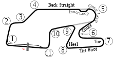
Descripción New version based on Image:Watkins_Glen_International_Track_Map.svg with white borders on some objects in case the background isn't white. New version adds the bus stop. The PNG version was updated for users of browsers like IE7 that don't support SVG.
Data 6-5-2008
Fonte Created by User:Will Pittenger with Inkscape
Autor User:Will Pittenger
Permisu
(Cómo reutilizar esti ficheru)
Public domain L'autor d'esta obra, Will Pittenger, la lliberó como dominiu públicu. Esto s'aplica nel mundu ensembre.

En dellos países seique esto nun seya posible llegalmente; nesti casu:
Will Pittenger da a cualesquier persona permisu pa usar esta obra pa cualesquier propósitu, ensin denguna condición, menos si eses condiciones requierense pola llei.

Otres versiones
SVG Version used to build this version of the PNG file
Posición de la cámara42° 20′ 10,8″ N, 76° 55′ 27″ O Kartographer map based on OpenStreetMap.Ubicación de esta y otras imágenes en: OpenStreetMapinfo
File:Watkins Glen International Track Map.svg es una versión vectorial de este archivo. Debería usarse esa versión en lugar de este archivo PNG, cuando sea mejor.

File:Watkins Glen International Circuit Map.png → File:Watkins Glen International Track Map.svg

Para más información, lee Ayuda:SVG.

En otros idiomas
Alemannisch  Bahasa Indonesia  Bahasa Melayu  British English  català  čeština  dansk  Deutsch  eesti  English  español  Esperanto  euskara  français  Frysk  galego  hrvatski  Ido  italiano  lietuvių  magyar  Nederlands  norsk bokmål  norsk nynorsk  occitan  Plattdüütsch  polski  português  português do Brasil  română  Scots  sicilianu  slovenčina  slovenščina  suomi  svenska  Tiếng Việt  Türkçe  vèneto  Ελληνικά  беларуская (тарашкевіца)  български  македонски  нохчийн  русский  српски / srpski  татарча/tatarça  українська  ქართული  հայերեն  বাংলা  தமிழ்  മലയാളം  ไทย  한국어  日本語  简体中文  繁體中文  עברית  العربية  فارسی  +/−
Nueva imagen SVG

Pies

Añade una explicación corta acerca de lo que representa este archivo

Elementos representados en este archivo

representa a

42°20'10.799"N, 76°55'27.001"W

Historial del ficheru

Calca nuna fecha/hora pa ver el ficheru como taba daquella.

Data/HoraMiniaturaDimensionesUsuariuComentariu
actual22:37 15 och 2009Miniatura de la versión a fecha de 22:37 15 och 2009999 × 503 (148 kB)Spyder MonkeyCorrected turn numbers and names (inner loop, outer loop)
05:22 6 xun 2008Miniatura de la versión a fecha de 05:22 6 xun 2008999 × 509 (148 kB)Will Pittenger{{Information |Description=New version based on Image:Watkins_Glen_International_Track_Map.svg with white borders on some objects in case the background isn't white. New version adds the bus stop. The PNG version was updated for users of browsers l
18:23 29 pay 2006Miniatura de la versión a fecha de 18:23 29 pay 2006470 × 490 (20 kB)AconcaguaWatkins Glen International Circuit Map {{Moved to commons|lt|Arz|21:42, 2006 Rugpjūčio 3}} {{PD-user-lt|Arz}} Category:Formula One circuits maps

Nun hai páxines qu'usen esti ficheru.

Usu global del ficheru

Metadatos