Ficheru:Weimar Republic states map.svg

Tamañu de la vista previa PNG d'esti ficheru SVG: 715 × 599 pixels. Otres resoluciones: 286 × 240 pixels | 573 × 480 pixels | 916 × 768 pixels | 1222 × 1024 pixels | 2444 × 2048 pixels | 976 × 818 pixels.
Ficheru orixinal (ficheru SVG, 976 × 818 píxels nominales, tamañu de ficheru: 949 kB)
Resume
| Descripción |
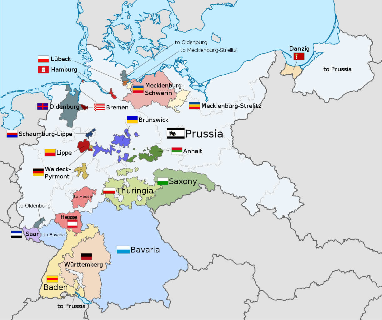
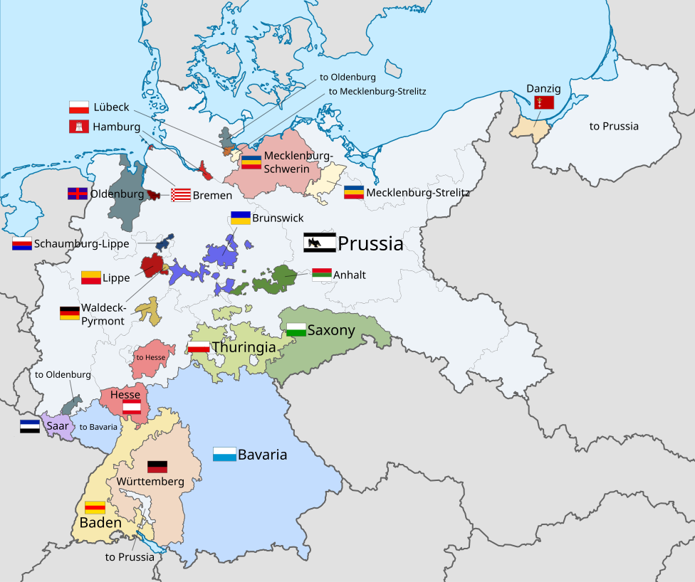
English: A map of the states of the Weimar Republic, showing their location, flags and names in English. |
| Data | |
| Fonte |
Este archivo deriva de: Weimar Republic blank map.svg: Esta imagen vectorial incluye elementos que han sido tomados o adaptados de esta: Esta imagen vectorial incluye elementos que han sido tomados o adaptados de esta: Esta imagen vectorial incluye elementos que han sido tomados o adaptados de esta: Esta imagen vectorial incluye elementos que han sido tomados o adaptados de esta: Esta imagen vectorial incluye elementos que han sido tomados o adaptados de esta: Esta imagen vectorial incluye elementos que han sido tomados o adaptados de esta: Esta imagen vectorial incluye elementos que han sido tomados o adaptados de esta: Esta imagen vectorial incluye elementos que han sido tomados o adaptados de esta: Esta imagen vectorial incluye elementos que han sido tomados o adaptados de esta: Esta imagen vectorial incluye elementos que han sido tomados o adaptados de esta: Esta imagen vectorial incluye elementos que han sido tomados o adaptados de esta: Esta imagen vectorial incluye elementos que han sido tomados o adaptados de esta: Esta imagen vectorial incluye elementos que han sido tomados o adaptados de esta: Esta imagen vectorial incluye elementos que han sido tomados o adaptados de esta: Esta imagen vectorial incluye elementos que han sido tomados o adaptados de esta: Esta imagen vectorial incluye elementos que han sido tomados o adaptados de esta: |
| Autor |
|
| Otres versiones |
|
| SVG desarrollo | El código fuente de esta imagen SVG es válido. Esta bandera fue creada con Inkscape This flag uses embedded text that can be easily translated using a text editor. |


.svg)


.svg)
.svg)
.svg)
.svg)
Llicencia
Yo, el titular de los drechos d'autor d'esta obra, la espublizo baxo la siguiente llicencia:
Esti ficheru ta disponible baxo la llicencia Creative Commons Reconocimientu-Compartir igual 3.0 xenérica.
- Ye llibre:
- pa compartir – pa copiar, distribuir y comunicar públicamente la obra
- pa remezclar – p'adautar la obra
- Baxo les condiciones siguientes:
- reconocimientu – Tienes de dar el créitu apropiáu, apurrir un enllaz a la llicencia ya indicar si realizasti dalgún cambéu. Puedes faelo de cualquier mou razonable ,pero non de manera que suxera l'encontu del autor pa ti o pal usu que faigas.
- compartir igual – Si entemeces, tresformes o te bases nesti material, tienes de distribuir les tos contribuciones baxo la mesma llicencia o una compatible cola orixinal.
Code for clickable map

Historial del ficheru
Calca nuna fecha/hora pa ver el ficheru como taba daquella.
| Data/Hora | Miniatura | Dimensiones | Usuariu | Comentariu | |
|---|---|---|---|---|---|
| actual | 22:22 17 avi 2021 | | 976 × 818 (949 kB) | Alphathon | Corrections to Anhalt and Brunswick |
| 03:28 5 pay 2015 |  | 976 × 818 (981 kB) | Alphathon | {{Information |Description={{en|A map of the states of the en:Weimar Republic, showing their location, flags and names in English.}}{{Valid SVG}} |Source={{Derived from|File:Weimar Republic blank map.svg|display=50}} {{AttribSVG|Flag of Prussia (... |
Usu del ficheru
La páxina siguiente usa esti ficheru:
Usu global del ficheru
Estes otres wikis usen esti ficheru:
- Usu en ar.wikipedia.org
- Usu en ca.wikipedia.org
- Usu en en.wikipedia.org
- Gleichschaltung
- Weimar Republic
- States of Germany
- Prussia
- Reichsrat (Germany)
- Reichsstatthalter
- States of the Weimar Republic
- Template:Weimar Republic States
- User:Falcaorib
- Provisional Law and Second Law on the Coordination of the States with the Reich
- Nazi Party election results
- Law on the Reconstruction of the Reich
- Usu en fa.wikipedia.org
- Usu en fy.wikipedia.org
- Usu en gd.wikipedia.org
- Usu en hy.wikipedia.org
- Usu en id.wikipedia.org
- Usu en it.wikipedia.org
- Usu en kk.wikipedia.org
- Usu en lt.wikipedia.org
- Usu en ms.wikipedia.org
- Usu en pt.wikipedia.org
- Usu en simple.wikipedia.org
- Usu en tr.wikipedia.org
- Usu en ur.wikipedia.org
- Usu en zh.wikipedia.org